São Paulo
São Paulo (pronounces AFI: [sɐ̃ w̃ pawlu] listen) is a Brazilian municipality, the capital of the homonymous state and the main financial, corporate and merchant center of South America. It is the most populous city in Brazil, in the American continent, in the Lusophone region and in the entire southern hemisphere. São Paulo is the most influential Brazilian city on the global stage, and in 2016 it is the 11th most globalized city on the planet, receiving the Globalization and World Cities Study Group & Network (GaWC)'s global alpha city rating. The motto of the city, present in its official coat, is Non ducor, duco, Latin phrase that means "I am not being driven, I am driving."
| |||
|---|---|---|---|
| Municipality of Brazil | |||
 | |||
| Symbols | |||
| |||
| Anthem | |||
| Theme | Non dvcor dvco "I'm not driving, I'm driving." | ||
| Surname(s) | "Land of Drizzle" "Sampa" "Pauliceia" | ||
| Gentyl | paulistan | ||
| Location | |||
| Coordinates | |||
| Country | Brazil | ||
| Federal Unit | São Paulo | ||
| Intermediate region | São Paulo | ||
| Immediate Region | São Paulo | ||
| Metropolitan Region | São Paulo | ||
| Border municipalities | 23
| ||
| Distance to capital | 1 015 km | ||
| History | |||
| Foundation | January 25, 1554 (466 years) | ||
| Administration | |||
| Districts | List
| ||
| Mayor | Bruno Covas (PSDB, 2018 - 2020) | ||
| Geographical characteristics | |||
| Total area | 1 521.11 km² | ||
| ・ Urban area EMBRAPA/2015 | 949,611 km² | ||
| Total population (IBGE/2019 statistics) | 12 252 023 live. | ||
| ・ Position | BR: 1st | ||
| Density | 8 054.7 inhabitants/km² | ||
| Climate | wet subtropical (Cfa) | ||
| Altitude | 760 m | ||
| Time zone | Brasilia Time (UTC-3) | ||
| Indicators | |||
| IDH (UNDP/2010) | 0.805 — very high | ||
| ・ Position | SP: 14 | ||
| GDP (IBGE/2016) | R$687,035,889.61,000 | ||
| ・ Position | BR: 1st | ||
| GDP per capita (IBGE/2016) | R$57,071.43 | ||
| Site | www.capital.sp.gov.br www.camara.sp.gov.br (Chamber) | ||


Founded in 1554 by Jesuit priests, the city is known worldwide and has significant national and international influence, whether from the cultural, economic or political point of view. It has important monuments, parks and museums, such as the Latin America Memorial, the Portuguese Language Museum, the Ipiranga Museum, MASP, Ibirapuera Park, the São Paulo Botanical Garden and Paulista Avenue, and events with major repercussions, such as the International Art Biennial, the Brazil Formula 1 Grand Prize, São Paulo Fashion Week and the Organ Parade LGBT noise.
The municipality has the 10th largest GDP in the world, accounting, in isolation, for 11% of all Brazilian GDP, 34% of the state's GDP, as well as 36% of all its production of goods and services, besides being the headquarters of 63% of the multinationals established in Brazil, and is still responsible for 28% of all national scientific production in 2005, and for more than 4% of the patents produced in the country. The city is also the headquarters of the B3 (Brazil acronym, Bolsa, Balcão), the world's fifth largest stock exchange in market capitalization (2017 data), a result of the merger of the São Paulo Stock Exchange, Goods and Future (BM&FBOVESPA) with the Central of Custody and Financial Settlement of Securities (CETIP)). São Paulo also concentrates many of the highest buildings in Brazil, such as the Mirante do Vale buildings, Italy, Altino Arantes and the Torre Norte buildings, among others.
The city is the 8th most populous on the planet and its metropolitan region, with around 21 million inhabitants, is the 10th largest urban agglomeration in the world. The capital of São Paulo also has a cosmopolitan character, given that in 2016 it had native inhabitants of 196 different countries. Regions around Greater São Paulo are also metropolises, such as Campinas, Santos Basin and Paraíba Valley; besides other nearby cities, which include urban agglomerations in the process of conurbation, like Sorocaba and Jundiaí. This complex of metropolises — the so-called Expanded Metropolitan Complex — reached 33 million inhabitants in 2017 (about 75% of the population of the state and 12% of the country's population), forming the first megalopolis of the southern hemisphere, responsible for the production of 80% of the São Paulo GDP and of almost 30% of the Brazilian GDP.
History
Foundation

The village of São Paulo in Piratininga arose on the 25th of January 1554, with the construction of a Jesuit school by twelve priests, among them Manuel da Nóbrega and José de Anchieta, on the top of a carped hill, between the Anhangabaú and Tamanduateí rivers. Such a college, which worked in a barracon made from a pylon beetle, had the purpose of catechism of the Indians who lived in the region of the Piratininga Plateau, separated from the coast by the Serra do Mar (Sea Ridge), called by the Indians "Serra de Paranapifim".
The name São Paulo was chosen because the day of the foundation of the school was January 25, the same day on which the Catholic Church celebrates the conversion of the apostle Paulo de Tarso, as Father José de Anchieta said in a letter to the Company of Jesus:
On the 25th of January of the Year of the Lord of 1554, we celebrated the first mass, in pauperia and very narrow house, on the day of the conversion of the Apostolo São Paulo, and for this reason we dedicated our house to it!— José de Anchieta
Colonial period
The settlement of the Patio region of the College began in 1560, when, on the visit of Mem de Sá, the governor-general of Brazil, to the Capitania of São Vicente, the latter ordered the transfer of the population of Vila de Santo André da Borda Campo, which had been created by João Ramalho in 1553, to the environs of the school, called "São Paulo College of Piratiniao Paulo inga", a high and more suitable place (a carpade hill next to a large fence, the Carmo Valley, on the one hand, and, on the other hand, the Anhangabaú Valley, on the other hand), in order to protect itself better from the attacks of the Indians. For being on a high hill, marched by two valleys (of the Tamanduateí and Anhangabaú rivers), it was safer than the Vila de Santo André da Borda do Campo (now the city of Santo André), close to the Serra do Mar (Serra do Mar), which was constantly threatened by more combative Indians.
During the next two centuries, São Paulo remained like a poor and isolated village of the center of gravity of the colony, the coast, and maintained itself by means of subsistence crops. São Paulo was, for a long time, the only village in the interior of Brazil. This isolation of São Paulo took place mainly because it was difficult to climb the Serra do Mar mountain range from Vila de Santos or from Vila de São Vicente to the Piratininga Plateau. Go up this one that was made by Father José de Anchieta. Mem de Sá, when he visited the Capitania of São Vicente, prohibited the use of the "Path of the Piraique" (today Piaçaguera), for the frequent attacks of the Indians.
On March 22, 1681, the Marquis de Cascais, owner of the Capitania of São Vicente, transferred the capital of the Capitania of São Vicente to the Vila de São Paulo, which became the "Head of Capitania". The new capital was set up on April 23, 1683, with major public celebrations.
As the poorest region of the Portuguese colony in America, in São Paulo the activity of the bandeirantes began, who dispersed themselves throughout the country to hunt for Indians because, being extremely poor, the people of São Paulo could not buy African slaves. They also went out looking for gold and diamonds. The discovery of gold in the region of Minas Gerais, in the 1690s, made the kingdom's attention turn to São Paulo.
The new Captaincy of São Paulo and Minas de Ouro was created on November 3, 1709, when the Portuguese crown bought the Capitania of São Paulo and the Capitania of Santo Amaro of its former donators. On July 11, 1711, the Vila de São Paulo was elevated to the category of city. Soon afterwards, around 1720, gold was found, by the bandeirantes, in the regions where the city of Cuiabá and the city of Goiás are to be found, a fact that led to the expansion of Brazilian territory beyond the Tordesillas Line.
When the gold ran out, at the end of the 18th century, the São Paulo economic cycle of sugarcane began, which spread throughout the hinterland of the São Paulo captaincy. Through the city of São Paulo, sugar production was sold to the port of Santos. At that time, the first modern road between São Paulo and the coast was built: Lorena's Pavement.
Imperial period

After the Independence of Brazil, which occurred where the Ipiranga Monument is today, São Paulo received the title of Imperial Cidade, conferred by Dom Pedro I do Brasil in 1823. In 1827, there was the creation of legal courses in the São Francisco Convention (which would give origin to the future Law School of the Largo de São Francisco), and this gave a new boost to growth to the city, with the flow of students and teachers, thanks to which, the city goes on to be called the Imperial City and Burg of the Students of São Paulo of Piratininga.
Another fatora in the growth of São Paulo was the expansion of the production of coffee, initially in the region of the São Paulo Paraíba Valley, and afterwards in the regions of Campinas, Rio Claro, São Carlos and Ribeirão Preto. From 1869 onwards, São Paulo started to benefit from a railroad that links the interior of the province of São Paulo to the port of Santos, the Ferro Santos-Jundiaí Highway, called The English.
At the end of the 19th century, several other railroads appeared that link the interior of the state to the capital, São Paulo. São Paulo then became the point of convergence of all the railroads coming from the interior of the state. The production and export of coffee allows the city and the province of São Paulo, afterwards called the State of São Paulo, to have a great economic and population growth.
From the middle of this century to the end, it was the period that the province began to receive a large quantity of immigrants, in a good part Italian, of which many settled in the capital, and the first industries began to install themselves.
Old Republic
With the end of the Second Reign and the beginning of the Republic, the city of São Paulo, as well as the state of São Paulo, has great economic and population growth, also aided by the coffee policy with milk and by the great European and Asian immigration to São Paulo. On the large number of immigrants in the capital of São Paulo, Cornélio Pires, in his book "Samba e Cateretês", collected a modinha, from 1911, by Dino Cipriano, which describes the impression that the man from the interior had of the capital city of São Paulo:

!Just one thing here in S. Pole that I've already put on notice: what you see is strangers! Brazilian is very rare!— Dino Cipriano
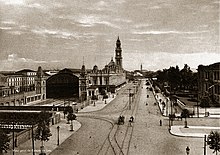
During the Old Republic (1889-1930), São Paulo went from a regional center to a national metropolis, industrializing itself and reaching its first million inhabitants in 1928. Its largest growth, in this period, relative took place, in the 1890s, when it doubled its population. The peak of the coffee period is represented by the construction of the second Luz Station (the current building) at the end of the 19th century and by Paulista Avenue in 1900, where many mansions were built.
The Anhangabaú river valley is courageous and the region on its left bank becomes known as the Centro Novo. The seat of the São Paulo government is transferred, at the beginning of the 20th century, from the Patio of the College to Campos Elísios. In 1922, São Paulo housed the Week of Modern Art, which was a landmark in the history of art in Brazil. In 1929, São Paulo won its first skyscraper, the Martinelli building.
The modifications carried out in the city by Antônio da Silva Prado, the Baron of Duprat and Washington Luís, which governed from 1899 to 1919, contributed to the climate of development of the city; some scholars consider that the entire city was demolished and rebuilt in that period.
With the industrial growth of the city in the 20th century, to which the difficulties of access to imports also contributed during the First World War, the urban area of the city began to increase, with some residential districts being built in places of the house. From the 1920s, with the rectification of the course of the Pinheiros river and the reversal of its waters to feed the Henry Borden Hydroelectric Plant, the flooding in the vicinity of that river ended, allowing it to spring up in the western part of São Paulo, high-standard lots known today as the "Jardins Region".
Also at the beginning of the 1920s, the São Paulo Revolt of 1924 occurred, an armed conflict that was waged in the working districts close to the center of the city of São Paulo and that lasted 23 days, from July 5 to 28, leaving hundreds dead and thousands wounded. The confrontation between the federal troops of President Artur Bernardes and part of the Brazilian army, was classified by the federal government as a conspiracy, riot and "revolt against the homeland, without foundation, headed up by disorderly members of the Brazilian army". Among the reasons that triggered the uprising were the Brazilian economic crisis, with the fall in exports after the First World War and the political crisis, with the dissatisfaction of some political groups with the concentration of power between representatives from the states of São Paulo and Minas Gerais. These groups formed the Republican Reaction movement, which asked for protection for all Brazilian products, not only for coffee, as was usual. The movement supported Nilo Peçanha in the 1922 elections, won by Arthur Bernardes, from Minas Gerais. Some military personnel opposed him taking over the presidency, which started the disagreements between the Armed Forces and the Federal Government, which culminated in the 1924 revolt.
At the end of the decade, more precisely between the years 1928 and 1933, cadastral plants of the municipality were drawn up on a scale of 1:5 000 and 1:1 000, this being the first carried out in Brazil and one of the first in the world for the use of aero-grammetry. He was one of the world's pioneers, with this the municipality of São Paulo gained a great deal of detail in its territory by means of the rapid execution of the aero-grammetry when compared with topographical surveys, a method previously used.
1932 revolution in contemporaneity
In 1932, São Paulo mobilized itself in its largest civic movement: the constitutionalist revolution, when the whole population is engaging in the war against Getúlio Vargas's "Interim Government." In 1934, with the gathering of some faculties created in the 19th century and the creation of others, the University of São Paulo (USP) is founded, today the largest in Brazil. Another major industrial outbreak occurred during World War II, due to the coffee crisis in the 1930s and restrictions on international trade during the war, which made the city have a very high rate of economic growth that remained high in the post-war period.
In 1947, São Paulo gained its first highway with asphalt: the Via Anchieta (built on the ancient route of the Path of Father José de Anchieta), links the capital to the São Paulo coast. In the 1950s, São Paulo was known as The city that cannot stop and as The city that grows the most in the world.
In 1954, São Paulo held a major celebration of the city's "Fourth Century'' foundation. The Ibirapuera Park is inaugurated, many historical books have been launched and the source of the Tietê river in Salesópolis has been discovered. With the transfer, from the 1950s onwards, of part of the city's financial center located in the historical center (in the region called the "Historical Triangle"), to Avenida Paulista, its mansions were, in its majority, replaced by large buildings.
In the period from the 1930s until the 1960s, the great entrepreneurs in the development of São Paulo were mayor Francisco Prestes Maia and the governor of the state of São Paulo Ademar de Barros, who was also the mayor of São Paulo between 1957 and 1961. Prestes Maia projected and implanted, in the 1930s, the "Avenue Plan for the City of São Paulo", which revolutionized the traffic in São Paulo.
These two rulers are also responsible for the two largest urban interventions, after the Avenue Plan, and which changed São Paulo: the rectification of the Tietê River with the construction of its marginals and the São Paulo Metro: on february 13, 1963, governor Ademar de Barros and mayor Prestes Maia created the commission (state and municipal) for studies for the preparation of the basic São Paulo Metro project, and set aside for Metro its first funds.
At the beginning of the 1960s, São Paulo had already added up to four million inhabitants. The São Paulo subway began to operate commercially on September 14, 1974, and in 2016 it had a network of 71.5 kilometers in length and 64 stations distributed over five lines. In that year, 1.1 billion passengers were transported by the system.
In 2008, the city of São Paulo ranked 56th in the ranking of the 75 most important centers of global trade, occupying the 3rd position in Latin America.

Geography
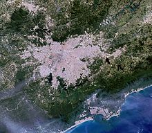
São Paulo is the capital of the most populous state of Brazil, São Paulo, located at latitude 23°33'01'' south and longitude 46°38'02'' west. The total area of the municipality is 1,521.11 km², according to the Brazilian Institute of Geography and Statistics (IBGE), the ninth largest in the state in territorial terms. Of the whole area of the municipality, 949,611 km² are urban areas (2015), being the largest urban area in the country.
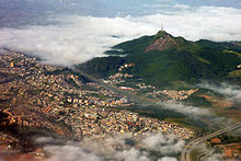
São Paulo has an average altitude of 760 meters. The culminating point of the municipality is the Pico do Jaraguá, at an altitude of 1,135 meters above sea level, located in the Jaraguá State Park, in the Cantareira mountains, where the second largest urban forest in the world is also to be found, in the Cantareira Park.
The intense conurbation process currently under way in Greater São Paulo has made the political boundaries between the municipalities of the region ineffective, creating a metropolis whose center is in São Paulo and reaches municipalities, such as Santo André, São Bernardo do Campo, São Caetano do Sul, Diadema (the so-called Greater ABC Region), Osasco and Guarulhos, among several others. The Metropolitan Region of São Paulo (RMSP) was created in 1973 and is currently made up of 39 municipalities, the largest urban agglomeration in Brazil and the third largest in the Americas, with 20 820 093 inhabitants. In 2009, its Gross Domestic Product (GDP) totaled some 613 billion Brazilian reais (approximately 15 billion US dollars).
Climate
The São Paulo climate is characterized as a humid subtropical (Cwa type according to Köppen), with dry winters and rainy summers with higher temperatures, autumn and spring being transition seasons. However, due to its altitude, São Paulo is experiencing temperate climate conditions. Precipitation falls mainly in the form of rain and, sporadically, hail, and may also be accompanied by electrical discharges and strong wind bursts. During the summer months, occurrences of convective rain, associated with heat and higher humidity, especially at the end of the afternoon, are common.
| Larger cumulative precipitation in 24 hours recorded in São Paulo (Mirante de Santana) for months (INMET, 1945-present) | |||||
|---|---|---|---|---|---|
| Month | Cumulated | Date | Month | Cumulated | Date |
| January | 127.4mm | 01/12/1949 | July | 123.6mm | 07/05/2019 |
| February | 123mm | 02/10/2020 | August | 53.2mm | 08/24/1953 |
| March | 106.2mm | 03/11/1994 | September | 78.1 mm | 09/09/2009 |
| April | 82.1 mm | 04/07/2017 | October | 72.7mm | 10/07/1991 |
| May | 140.4mm | 05/25/2005 | November | 103.2mm | 11/27/1950 |
| June | 89.6 mm | 06/27/2020 | December | 151.8mm | 12/21/1988 |
On the other hand, in winter, when the frequency of rainfall is lower, the relative humidity of the air (URA) falls, sometimes to below 30%, making it difficult to disperse pollutants and favoring air pollution. At that time, however, it is more common to have polar air masses which help to bring down temperatures, some of which are stronger to 10 °C or less. The lowest maximum temperature recorded in São Paulo since the beginning of the measurements (in 1961) was 8.7 °C on July 24, 2013. Snows occur when there is a combination of high humidity and low temperatures, while the frost occurs sporadically in regions further from the center and, in stricter winters, in a good part of the municipality.
According to data from the conventional meteorological station of the National Meteorology Institute (INMET) in the Mirante de Santana, the municipality's official, since 1945, had the lowest temperature recorded in São Paulo at -2.1 °C on August 2, 1955 and the highest temperature reached 37.8 °C on October 17, 2014, exceeding the previous mark of 37 °C observed on 20 January 1999. The largest accumulation of rainfall observed in 24 hours reached 151.8 mm on 21 December 1988. March 2006, with 607.9 mm, was the month of the highest rainfall followed by February 2020 (505.7 mm). The lowest UR index was registered on the afternoon of August 14, 2009, at 10%. Since July 2006, when INMET entered the same location, the largest wind burst reached 24.6 m/s (88.6 km/h) on January 30, 2019.
| Climatological data for São Paulo (Mirante de Santana) | |||||||||||||
|---|---|---|---|---|---|---|---|---|---|---|---|---|---|
| Month | Jan | Feb | Sea | Apr | Mai | Jun | Jul | Aug | Set | Oct | Nov | Dec | Year |
| Record maximum temperature (°C) | 37 | 36.4 | 34.3 | 33.4 | 31.7 | 28.8 | 30.2 | 33 | 37.1 | 37.8 | 36.1 | 34.8 | 37.8 |
| Average maximum temperature (°C) | 28.2 | 28.8 | 28 | 26.2 | 23.3 | 22.6 | 22.4 | 24.1 | 24.4 | 25.9 | 26.9 | 27.6 | 25.7 |
| Mean temperature compensated (°C) | 22.9 | 23.2 | 22.4 | 21 | 18.2 | 17.1 | 16.7 | 17.7 | 18.5 | 20 | 21.2 | 22.1 | 20.1 |
| Average minimum temperature (°C) | 19.3 | 19.5 | 18.8 | 17.4 | 14.5 | 13 | 12.3 | 13.1 | 14.4 | 16 | 17.3 | 18.3 | 16.2 |
| Record minimum temperature (°C) | 10.2 | 11.1 | 11 | 6 | 3.7 | 1 | 0.4 | -2.1 | 2.2 | 4.3 | 7 | 9.4 | -2.1 |
| Precipitation (mm) | 288.2 | 246.2 | 214.5 | 82.1 | 78.1 | 50.3 | 47.8 | 36 | 84.8 | 126.6 | 137 | 224.4 | 1.616 |
| Days precipitated (≥ 1 mm) | 16 | 14 | 13 | 7 | 7 | 4 | 4 | 4 | 7 | 10 | 10 | 14 | 110 |
| Compensated relative humidity (%) | 77.2 | 76 | 77.1 | 75.3 | 75.6 | 73.2 | 71.6 | 69.4 | 72.5 | 74.3 | 73.6 | 75.5 | 74.3 |
| Sunset hours | 139.1 | 153.5 | 161.6 | 169.3 | 167.6 | 160 | 169 | 173.1 | 144.5 | 157.9 | 151.8 | 145.1 | 1 893.5 |
| Source: National Meteorological Institute (INMET) (climate standard 1981-2010; temperature records: 1945-present) | |||||||||||||
Hydrography
Marginal Tietê and River Tietê | Billings dam |
São Paulo is located near the basin of the Tietê river, with the sub-basins of the Pinheiros river and the Tamanduateí river having important roles in its configuration. Its rivers have already been an important source of fresh water and leisure. However, heavy industrial effluents and wastewater discharges at the end of the 20th century caused rivers to become heavily polluted. A substantial clean-up program for both rivers is under way (see the Tietê Project), financed through a partnership between the local government and the international development banks, such as the Inter-American Development Bank (BID). The river is inland on the stretch that runs through the city, although the transport of water becomes increasingly important in the river Tietê due to the Tietê-Paraná river.
There are no large natural lakes in the region, but the Billings and Guarapiranga reservoirs in the suburbs of the south of the city are used for generating energy, storing water and leisure activities. The original flora of the area consisted mainly of perennial angiosperms. Non-native species are common, mild climate and abundant rainfall allow the multitude of tropical, subtropical and temperate plants to be cultivated, especially the omnipresent eucalyptus.
The northern part of the municipality contains part of the Cantareira State Park of 7,917 hectares, created in 1962, which protects a large part of the São Paulo metropolitan water supply. In 2015, São Paulo experienced a major drought, which led several cities in the state to initiate the rationing system.
Environmental problems
The pollution of the air in the municipality is intense, mainly due to the enormous quantity of automobiles that circulate daily in their streets, avenues and highways. The World Health Organization (WHO) sets a limit of 20 micrograms of particulate matter per cubic meter of air as a safe annual average. In an evaluation carried out by the WHO of one thousand more cities around the world in 2011, the city of São Paulo was classified in the 268th position amongst the most polluted, with an average rate of 38 micrograms per cubic meter, an index well above the limit imposed by the organization, but lower than that of other Brazilian cities, like Rio de Janeiro (64 micrograms per cubic meter). A 2013 study indicated that air pollution in the city causes more deaths than traffic accidents.
Besides air pollution, the municipality has serious problems due to water pollution, concentrated mainly on its two main rivers, the river Tietê and the river Pinheiros, which are highly degraded and are some of the country's most polluted rivers. Since 1992, however, the river Tietê has undergone a clean-up program that has already cost 2.7 billion dollars.
The problem of the balanced supply of water to the city - and to the metropolis in general - is also a worrying one: São Paulo has few sources of water at its own perimeter, having to look for it in distant water basins. The problem of water pollution is also aggravated by the irregular occupation of the water supply areas, brought about by urban expansion, driven by the difficulty of access to land and housing in central areas by the low income population and associated with property speculation and precariousness in the new building lots. This also leads to an overvaluation of individual transport over collective transport - leading to the current rate of more than one vehicle per two inhabitants and aggravating the problem of environmental pollution.
Parks and biodiversity
 | ||
Cantareira State Park, part of the Biosphere Reserve of the Green Belt of São Paulo | People's Park located in Itaim Bibi District, West Zone |
In 2010, São Paulo owned 62 municipal and state parks, such as the Cantareira State Tourist Park, part of the São Paulo Green Belt Biosphere Reserve, which houses one of the largest urban forests on the planet with 7,900 hectares in length, the Ipiranga State Park Fontes, Ibirapuera Park, the Tietetete Ecological Park ê, the Jaraguá State Park, which was overtaken by Unesco as a World Heritage Site in 1994, the Capivari-Monos Environmental Protection Area, the Serra do Mar State Park, the Anhanguera Park, the Villa-Lobos Park, the People's Park, among others.
In 2009, São Paulo had 2,300 hectares of green area, less than 1.5% of the city's area and below the 12 m² per inhabitant recommended by the World Health Organization (WHO). Around 21% of the municipality's area is covered by green areas, including ecological reserves (2010 data).
In the municipality it is possible to observe forest birds that generally appear in the spring, due to the belt of native forest that still surrounds the metropolitan region. Species like orange-mockingbird, blood, well-seen and hummingbird are the most common. In spite of intense pollution, the main rivers of the city, the Tietê and Pinheiros, house various species of animals such as capivaras, hawks, I want-want, African waiters and rats from the bathwater. Other species found in the municipality are the red brocket, the red brocket, the red brocket and the wild boar.
Demographics
| Population growth | |||
|---|---|---|---|
| Census | Pop. | %± | |
| 1872 | 31 385 | ||
| 1890 | 64.934 | 106.9% | |
| 1900 | 239.620 | 269.0% | |
| 1920 | 579,033 | 141.6% | |
| 1940 | 1.326.261 | 129.0% | |
| 1950 | 2 198 096 | 65.7% | |
| 1960 | 3.825.351 | 74.0% | |
| 1970 | 5.978.977 | 56.3% | |
| 1980 | 8.587.665 | 43.6% | |
| 1991 | 9.626.894 | 12.1% | |
| 2000 | 10.405.867 | 8.1% | |
| 2010 | 11.253.503 | 8.1% | |
| Here. 2018 | 12.176.866 | 8.2% | |
| IBGE Demographic Census | |||
São Paulo was the Brazilian capital that grew the most in the entire twentieth century, reaching the mark of one million inhabitants in the 1930s and configuring itself as the most populous municipality in Brazil since 1960, when it surpassed Rio de Janeiro. In the 2010 demographic census, the municipality's population was the Brazilian Institute of Geography and Statistics (IBGE) of 11 253 503 inhabitants, with a population density of 7 387.69 inhabitants per square kilometer.
According to the same census, 5 924 871 were female (52.65%) and 5 328 632 were male (47.35%). Also according to the same census, 11 152 344 inhabitants lived in the urban area (99.1%) and 101 159 in the rural area (0.9%). In that year, the most populous district of São Paulo was Grajaú, with 360 787 inhabitants, and Marsilac, in the far south of the municipality, the least populous, with a population of 8 258 people. For 2019, the population estimate is 12 252 023 inhabitants.
Human Development
The municipality has a very high Human Development Index (HDI) (0.805), the 14th largest in the state and the 28th largest in Brazil. However, the distribution of human development in the city is not homogeneous. The most central districts in general have HDI greater than 0.9, gradually decreasing as they move away from the center, to the point of about 0.7 at the municipality's borders.
The social difference between the central regions and the outskirts is due to historical issues, since the central area, above all the one located between the Pinheiros, Tietê and Tamanduateí rivers, was the place where the investments and urban planning by the public authorities were most concentrated, as well as where, historically, almost the entire economic elite of the city was installed. The populations with the lowest income, for not having the cost of living in these areas, end up occupying the areas on the edges of the municipality, most devoid of infrastructure.
A world quality of life ranking, drawn up by the international consultancy in human resources, Mercer, points to the capital of São Paulo in 117th place between 221 cities and the third place among the four Brazilian cities in the ranking, behind only Curitiba, Florianópolis and Porto Alegre, and ahead of Brasilia. The ecological status in a parallel ranking points to the city in 148th position.
The city's Gini index, which measures social inequality, is 0.62. The districts of Vila Andrade, Vila Sônia and Tremembé have the greatest economic disparity. All the indices are published in the Atlas of Labor and Development of São Paulo, an electronic tool that houses more than two hundred socioeconomic indicators of the capital.
Immigrants and migrants
São Paulo is the most multicultural city in Brazil and one of the most diverse in the world. Since 1870, approximately 2.3 million immigrants have arrived in the state from all over the world. Today, it is the city with the largest ethnic populations in Italy, Portugal, Japan, Spanish, Lebanese and Arabic outside their respective countries, and with the largest number of northeastern countries outside the Northeast. In the 2010 census, of the total population, 60.63% were white, 30.63% brown, 6.37% black, 2.22% yellow and 0.12% indigenous, besides 0.03% undeclared.
The Italian community is one of the strongest, with its presence in the whole city. Of the ten million inhabitants of São Paulo, 60% (six million people) have some Italian ancestry. São Paulo has more descendants of Italians than any other Italian city (the largest city in Italy is Rome, with 2.5 million inhabitants). Even today, Italians group together in districts like Bixiga, Brás and Mooca to promote celebrations and festivals. In 1870, as the beginning of the substitution of slave labor by European immigrants, the Italian population in São Paulo was 30,000 people. At the beginning of the 20th century, this population had leapt to 240,000 people. São Paulo is the second largest pizza-consuming city in the world (2007 data). There are six thousand pizza shops producing about one million pizzas a day (2008 data).
The Portuguese community is also quite numerous, and it is estimated that three million people from São Paulo have some origin in Portugal. The Jewish colony represents more than 60,000 people in São Paulo and is concentrated mainly in Higienópolis (greater presence) and Bom Retiro (a smaller presence at the moment). From the 19th century onwards, and especially during the first half of the 20th century, São Paulo also received German immigrants (in the current district of Santo Amaro), Spanish and Lithuanian (in the district of Vila Zelina). We can also highlight the important Armenian community, with its various institutions located in the vicinity of the Bom Retiro neighborhoods, near the Armenia Metro Station Imirim and Brás. The Armenians made the trade and the manufacturing of footwear their main activities. With the decadence of European and Asian immigration after the decade of the 1930s, the arrival of migrants began to predominate, in their majority coming from the Northeast region of Brazil.
The city had already had an Afrodescending population in the 19th century, but it was as from the second half of the 20th that the population of African origin grew rapidly, through the arrival of people from other Brazilian states, mainly from the coastal zone of Bahia. According to the IBGE, in the 2000 Census, 30.3% of the São Paulo population had some African descent; in other words, they declared themselves "black" and "brown".
Freedom neighborhood, Japanese community stronghold | A Syrian Bazaar in 1940 |
One of the most striking colonies in the city is that of Arab origin. The Lebanese and Syrians arrived in large numbers from 1900 to 1930. Today, its descendants are totally integrated with the Brazilian population, although cultural aspects of Arab origin have until today marked the culture of the São Paulo capital. Arab food restaurants are abundant all over the city, selling dishes that have now definitely entered Brazilian cuisine: chibe, esfiha, cabbage, etc. March 25th street was created by the Arabs, who were mostly traders.
The city of São Paulo has the largest number of people who declare themselves of Asian (yellow) origin in Brazil. Around 456,000 people are of oriental origin, of which 326,000 are Japanese. The city's Japanese community is the largest outside Japan. Immigrants from Japan began to arrive in 1908, and immigrated in large numbers until the 1950s. The largest concentration of orientals in the city is in the Freedom district. This district of São Paulo has numerous Japanese restaurants, stores with typical Japanese parts, and you see signs written in Japanese and you hear a lot about the language. The Korean colony of the city is also remarkable. There are over 60,000 people of South Korean origin, particularly concentrated in Bom Retiro, Aclimation and Liberty. In the Aclimação neighborhood, several Korean restaurants can be found, as well as Korean video stores and groceries. The Chinese are quite numerous in the central districts of the city, such as Brás and Liberdade. In 2016, the municipality owned at least one native resident from 196 different countries, according to data from the Federal Police Department.
Sexual diversity
Greater São Paulo houses an important community of homosexuals, bisexuals and transgenders, of which 9.6% of the male population and 7% of the female population declares themselves to be non-heterosexual. The same-sex civil union has been legalized across the country since May 5, 2011, while homosexual marriage in São Paulo was legalized on December 18, 2012. Since 1997, the city has been hosting the São Paulo LGBT Pride Parade every year, considered the world's largest LGBT parade by Guinness World Records, with more than 5 million participants. The event typically rivals the New York parade by the public record.
The event is supported by the state and municipal government. In 2010, the São Paulo City Hall invested 1 million reais (about 2,000 US dollars) at the stop and relied on a solid security plan, with around 2,000 police officers, two mobile police stations for the immediate reporting of occurrences, 30 ambulances equipped, 55 nurses, 46 doctors, three hospital camps with 80 beds. The parade, considered to be the second largest event in the city after Formula 1, begins at the São Paulo Art Museum, crosses Avenida Paulista, and follows on Consolação Street to Roosevelt Square, in the center of São Paulo. According to the Grindr application, the city's LGBT march was elected the best in the world.
Religions
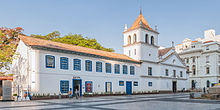
The St. Square and the Metropolitan Cathedral | Inside the Monastery of São Bento |
Like the cultural variety that can be verified in São Paulo, there are several religious manifestations present in the city. Although it has developed over an eminently Catholic social matrix, both because of colonization and immigration — and even today the majority of São Paulo state claims to be Catholic —, dozens of different Protestant names can currently be found in the city, as well as the practice of Islamism, spiritualism, among others.
Buddhism and oriental religions also have relevance among the beliefs most practiced by the people of São Paulo. It is estimated that there are more than a hundred thousand Buddhist, Seichonoite and Hinduist followers. The Jewish, Mormon and Afro-Brazilian communities are also considerable.
According to figures from the Brazilian Institute of Geography and Statistics (IBGE), in 2010, there were Apostolic Roman Catholic municipality (58.2%), Protestants (22.11%), Spirits (4.73%), Jehovah's Witnesses (0.9%), Buddhists (0.67%), Umbandistas well. 0.45%), Jews (0.39%), Brazilian Apostolic Catholics (0.25%), Eastern Religions (0.23%), Candomblecists (0.16%), Mormon (0.15%), Orthodox Catholics (0.13%), spiritualists (0.08%), Islamists (0.07%), esoterics (0.06%), indigenous traditions (0.02%) and Hinduists (0.01%). Another 9.38% had no religion, 1.33% followed other Christian religions, 0.5% had an undetermined religion or multiple membership, 0.13% did not know and 0.02% stated that they followed other religions.
 |  | |
Temple of Solomon, headquarters of the Universal Church of the Kingdom of God | São Paulo Orthodox Metropolitan Cathedral |
The Catholic Church divides the territory of the municipality of São Paulo into four ecclesiastical districts: the Archdiocese of São Paulo, the Roman Catholic of Santo Amaro, the Roman Catholic of São Miguel Paulista and the Roman Catholic of Campo Limpo, the latter three being the last superfragments of the former. The archive of the archdiocese, called the Metropolitan Archive Dom Duarte Leopoldo e Silva, located in the Ipiranga district, keeps one of the most important documentary heritage in Brazil. The Holy Archieptical is the Metropolitan Cathedral of São Paulo (known as the Cathedral of the Sé), located in the Sé Square, considered one of the five largest gotic temples in the world. The Catholic Church recognizes as priests of the city of São Paulo de Tarso and Our Lady of Penha de France.
The city has the most diverse Protestant or retired creeds, such as the Evangelical Community Sahara Terra, the Maranata Christian Church, the Lutheran Church, the Presbyterian Church, the Methodist Church, the Anglican Episcopal Church, the Baptist churches, the Assembly of God Church, the Seventh Day Adventist Church, the World Church of the Power of God, the Universal Church of the Kingdom of the Kingdom of God The Christian Congregation in Brazil, among others, besides Christians of various other names.
Public security and crime

In 2008, the city of São Paulo ranked 493rd on the list of Brazil's most violent cities. Among the capitals, it was the fourth least violent, recording, in 2006, murder rates higher than those of Boa Vista, Palmas and Natal. In November 2009, the Ministry of Justice and the Brazilian Public Security Forum released a survey that pointed to São Paulo as the safest Brazilian capital for young people. Between 2000 and 2010, the city of São Paulo reduced its homicide rate by 78%.
According to the Global Homicide Study 2011, released by the United Nations (UN), in the period from 2004 to 2009 the homicide rate fell from 20.8 to 10.8 murders per hundred thousand inhabitants. In 2011, the UN pointed out São Paulo as an example of how large cities can reduce crime. In a survey on the Adolescence Homicide Index (IHA) in 2010, the city of São Paulo was considered the least lethal for adolescents, out of 283 municipalities surveyed, with more than one hundred thousand inhabitants. According to data from the "Map of Violence 2011", published by the Sangari Institute and by the Ministry of Justice, in that year the city of São Paulo had the lowest homicide rate per hundred thousand inhabitants among all the Brazilian capitals.
The crime indicators, such as homicide, according to April 2017 data, showed a reduction in the capital city of São Paulo, compared with 2016. In the same period, there was a 12.64% reduction in homicides, the number of records of latrocination fell from eleven to seven (a reduction of 34%), and there was a reduction of 8.09% in cases of rape. The 9th DP of the Carandiru neighborhood was considered in March 2007, one of the top five police stations in the world and the best in Latin America.
Government
Because it is the capital of the state of São Paulo, the city is the seat of the Bandeirantes Palace (State Government) and of the Legislative Assembly.
The Executive Power of the municipality of São Paulo is represented by the mayor and his secretary's office, following the model proposed by the Federal Constitution. The organic law of the municipality and the current Master Plan of the city, however, determine that the public administration must guarantee the population effective tools for demonstrating participative democracy, which means that the city is divided into subprefectures, each one of which is led by a submayor appointed by the mayor.
The Legislative Power is represented by the municipal council, which consists of 55 councilors elected to office for four years (in accordance with Article 29 of the Constitution, which governs a minimum of 42 and a maximum of 55 for municipalities with more than five million inhabitants). It is up to the house to draw up and vote on fundamental laws for the administration and the executive, especially the municipal budget (known as the Budget Guidelines Law).
In addition to the legislative process and the work of the secretariats, there are also a number of municipal councils, each dealing with different themes, made up of representatives from the various sectors of organized civil society. The effective performance and representativeness of such advice, however, are sometimes questioned. The following municipal councils are currently active: Municipal Council of the Child and Adolescent (CMDCA); IT (IGH); Physical Disabilities (CMDP); education (EMC); Housing (CMH); the Environment (CADES); Health (CMS); Tourism (COMTUR); Human Rights (OHCHR); Culture (CMC); Social Assistance (COMAS) and Drugs and Alcohol (COMUDA).
Also belonging to the city hall (or this majority partner in its social capital) is a series of companies responsible for various aspects of the public services and the economy of São Paulo:

- São Paulo Tourism S/A (SPTuris): company responsible for organizing major events and promoting tourism in the city;
- Traffic Engineering Company (CET): subordinate to the Municipal Department of Transport, is responsible for the supervision of traffic, the imposition of fines (in cooperation with the DETRAN) and the maintenance of the city's road system;
- São Paulo Metropolitan Housing Company (COHAB): subordinate to the Housing Bureau, is responsible for the implementation of public housing policies, in particular the construction of housing units;
- Municipal Urbanization Company of São Paulo (EMURB): subordinate to the Planning Bureau, is responsible for urban construction and maintenance of public spaces and urban furniture;
- Information and Communication Technology Company of the Municipality of São Paulo (PRODAM): the head of the city hall's electronic and IT infrastructure;
- São Paulo Transportes Sociedade Anônima (SPTrans): responsible for the operation of the public transport systems managed by the city hall, such as municipal bus lines.
International relations
The sister cities of the city of São Paulo are regulated by Law No 14 471/2007 and other decrees.
- Amman, Jordan
- Assumption, Paraguay
- Belmonte, Portugal
- Bucharest, Romania
- Buenos Aires, Argentina
- Cluj-Napoca, Romania
- Chicago, United States
- Coimbra, Portugal
- Córdoba, Spain
- Erevan, Armenia
- Funchal, Portugal
- Gols, Portugal
- Hamburg, Germany
- Havana, Cuba
- Mendoza, Argentina
- Miami, United States
- Milan, Italy
- La Paz, Bolivia
- Leiria, Portugal
- Lisbon, Portugal
- Luanda, Angola
- Montevideo, Uruguay
- Santiago, Chile
- Toronto, Canada
- Damascus, Syria
- Macao, China
- Naha, Japan
- Ningbo, China
- Osaka, Japan
- Beijing, China
- Póvoa de Varzim, Portugal
- Santiago de Compostela, Spain
- Seoul, South Korea
- Tel Aviv, Israel
Subdivisions
Subdivisions of the municipality of São Paulo | ||
| Location | Population | Area |
| Zone | est. of 2008 | in km² |
| Central ' | 328 597 | 31 |
| Central-South | 715 910 | 74 |
| East 1 | 1 212 099 | 140 |
| East 2 | 1 342 924 | 68.8 |
| North | 1 181 582 | 152 |
| Northwest ' | 1 007 691 | 144 |
| West | 872 817 | 128 |
| Southeast | 1 494 770 | 128 |
| South | 2 346 913 | 607 |
São Paulo | 10 940 311 | 1509 |
| Source: | ||
The municipality of São Paulo is administratively divided into thirty-two regions administered by regional prefectures, each one of which is divided into districts, the latter being eventually subdivided into subdistricts (the name "district", however, does not officially exist, although it is usually applied by the population). The current districts were created by municipal law No 11 220 of 20 May 1992, and the current subprefectures by municipal law No 13 399 of 1 August 2002. The subprefectures are officially grouped into nine regions (or "zones"), taking into account the geographical position and history of occupation. Meanwhile, certain bodies and institutions (telephone companies, electoral areas, etc.) adopt a different division from the official one. It is up to the subprefectures to provide ordinary services to the population, in this way, decentralizing some routine services.
The official political division of the city takes into account both the historical and cultural characteristics of the different districts of São Paulo and practical factors (such as the division of two subprefectures into an important avenue). However, such a division often does not reflect the socio-spatial perception of the local population of the places: there are regions of the city that are not officially recognized by the city hall, so that their delimitation is informal and covers different districts and subprefectures, maintaining the name by tradition, physical contiguity or ease of localization. The phenomenon tends to repeat itself all over the city and considered in a broad manner, it may lead to the non-identification of the inhabitants with the local political bodies.
Besides the political division, there is also a division into nine geographical zones, each one of them represented by different colors on street signs and in the color of the buses that circulate in the region. These regions are established radially, using topographical criteria only, and, with a few exceptions, do not have an urban homogeneity or any administrative distinction, with the exception of the historic center and the expanded center, where the municipal rotation takes place.
| Subprefectures in the municipality of São Paulo | ||||||||
|---|---|---|---|---|---|---|---|---|
| Region | Area | Population | Region | Area | Population | |||
| 1 | Aricanduva/Vila Formosa | 21.5 km² | 266,838 | 17 | Mooca | 35.2 km² | 305,436 | |
| 2 | Butantan | 56.1 km² | 345.943 | 18 | Painters | 353.5 km² | 110.909 | |
| 1 | Cleaned Field | 36.7 km² | 508.607 | 19 | Penha | 42.8 km² | 472 247 | |
| 4 | Relief Chapel | 134.2 km² | 561,071 | 20 | Turkeys | 57.2 km² | 109.218 | |
| 5 | Green House/Dog | 26.7 km² | 313.176 | 21 | Pine | 31.7 km² | 270.798 | |
| 6 | Ademar City | 30.7 km² | 370.759 | 22 | Pirituba/Jaraguá | 54.7 km² | 390,083 | |
| 7 | Tiradentes City | 15 km² | 248.762 | 23 | Sé | 26.2 km² | 373 160 | |
| 8 | Ermelino Matarazzo | 15.1 km² | 204.315 | 24 | Santana/Tucuruvi | 34.7 km² | 327.279 | |
| 9 | Freguesia of Ó/Brasilândia | 31.5 km² | 391,403 | 25 | Jaçanã/Tremembé | 64.1 km² | 255,435 | |
| 10 | Guaianases | 17.8 km² | 283.162 | 26 | Santo Amaro | 37.5 km² | 217 280 | |
| 11 | Ipiranga | 37.5 km² | 427.585 | 27 | São Mateus | 45.8 km² | 422 199 | |
| 12 | Itaim Paulista | 21.7 km² | 358.888 | 28 | São Miguel Paulista | 24.3 km² | 377,540 | |
| 13 | Itaquera | 54.3 km² | 488.327 | 29 | Sapopemba | 13.4 km² | 296,042 | |
| 14 | Jabaquara | 14.1 km² | 214.200 | 30 | Vila Maria/Vila Guilherme | 26.4 km² | 302.899 | |
| 15 | Lapa | 40.1 km² | 270.102 | 31 | Vila Mariana | 26.5 km² | 311 019 | |
| 16 | M'Boi Mirim | 62.1 km² | 523.138 | 32 | Vila Prudente | 33.3 km² | 480.823 | |
Economics

São Paulo has the highest GDP among the Brazilian cities, the 10th largest in the world, and, according to PricewaterhouseCoopers projection, it will be the sixth largest in 2025. According to data from the Brazilian Institute of Geography and Statistics (IBGE), in 2016, its Gross Domestic Product (GDP) was 687,035,889.61 real, which is equivalent to about 11% of the Brazilian GDP, 34% of the GDP, as well as 36% of all the production of goods and services, in the state of São Paulo, and 2 11% of the economy of the southeast region.
According to a survey published by the Federation of Trade in Goods, Services and Tourism of the State of São Paulo (Fecomercio), if it were a country, the city of São Paulo could be classified as the 36th largest economy in the world, above nations like Portugal, Finland and Hong Kong. According to the same study, the municipality has 63% of the international groups installed in the country and 17 of the 20 largest banks.
Its metropolitan region has a GDP of about 613 billion reais (2009 data). According to data from the IBGE, the urban network of influence exercised by the city in the rest of the country covers 28% of the population and 40.5% of the Brazilian GDP.
The capital city of São Paulo is the sixth city in the world in number of billionaires, according to the listing of the magazine Forbes considers as a reference the main address of the 1,210 billion people on the magazine's 2011 list, based on values converted to the US dollar. However, the 2008-2009 financial crisis affected the average per capita household income of the inhabitants of São Paulo, which in 2008 was 816.40 Brazilian reais (81.40 US dollars), which positions the city in its eighth place in the Brazilian capital ranking, behind Florianópolis, Porto Alegre re, Vitória, Brasília, Curitiba, Rio de Janeiro and Belo Horizonte.
According to a survey by Mercer's consultancy on the cost of living for foreign workers, São Paulo is among the ten most expensive cities in the world, ranked 11 in 2011, 11 jobs above its 2010 rating, and in front of cities like London, Paris, Milan and New York.
One of the largest financial centers in Brazil and in the world, São Paulo is today undergoing a transformation in its economy. For a long time the industry was an economic activity very present in the city, but São Paulo has undergone a clear change in its economic profile over the last three decades: from a city with a strong industrial character, the municipality has increasingly taken on the role of a tertiary city, a service and business center for the country. In São Paulo, for example, B3 (acronym for Brazil, Bolsa, Balcão), the official scholarship of Brazil, is located. B3 had, in 2017, a 13 billion dollar asset. São Paulo ranked second after New York in the 2013/14 FDI magazine of the "Cities of the Future" in the Americas, and the Latin American city of the Future 2013/14 was named, overtaking Santiago de Chile, the first city in the previous ranking. Santiago now occupies second place, followed by Rio de Janeiro, the study also indicates that São Paulo has received more Direct Foreign Investments than New York.
The municipality has some financial centers spread over its territory, concentrated in the sub-prefectures of Sé, Pinheiros and Santo Amaro. The main and most famous of them is Avenida Paulista, which houses the seats of banks, multinationals, hotels, consulates and imposes itself as one of the main tourist and cultural points of the city. The city center, which despite being overshadowed by the latest economic centralities, houses the stock exchange, various companies and hotels. Besides these, other regions that stand out for their intense and modern vertically, for the presence of luxury hotels and multinational companies are the regions of Brigadeiro Faria Lima and Luís Carlos Berrini Avenues.
Many analysts have also pointed out São Paulo as an important "global city" (or "global metropolis", a classification divided only with Rio de Janeiro among Brazilian cities). As a global city, São Paulo has access to the world's main air routes, to the main information networks, as well as to the subsidiaries of transnational companies of global importance, as well as important financial institutions, even though they are marginally connected to the transnational flows of people, investments and jobs.
The urbanist João Sette Whitaker Ferreira, however, considers that social inequality and spatial segregation are decharacterizing São Paulo as a global city. In spite of being the country's financial center, São Paulo also has a high index of business linked to the informal economy. In this same scenario, according to 2001 data from the municipality's prefecture, about 10% of São Paulo inhabitants lived below the poverty line.
The city of São Paulo has also consolidated itself in a hub for the trade of smuggled, pirated and falsified products, in general located in some points of the city center such as the 25th of March Street, the Santa Ifigenia Street and areas close to the subway stations. The articles are usually CDs with pirated versions of software, films or albums on CDs and DVDs, or accessories and items of clothing, mainly rucksack and tennis shoes of international brands, among other articles. In recent years, however, the seizure of these pirated articles has grown.
Tourism


São Paulo stands out more as a city marked by business tourism than by recreational tourism. Large hotel networks whose target audience is the corporate are installed in the city and have branch offices spread across several of their centers. All the infrastructure for the city's events makes it the headquarters of 75% of the country's main fairs. Among the main ones are the São Paulo Automobile Room, Couromoda and Francal, amongst others. The city still promotes one of the most important fashion weeks in the world, São Paulo Fashion Week, being one of the main centers that generate fashion trends.
Cultural tourism also has relevance for the city, especially when one looks at the various international events that take place in the metropolis, such as the São Paulo Art Biennial and the various spectacles of foreign celebrities that, when they present themselves in Brazil, choose few metropolises. Furthermore, the LGBT Pride Parade of São Paulo, which has been happening since 1997 on Paulista Avenue in favor of combating homophobia, is the event that attracts more tourists to the city.
The city has numerous cultural activities and a night life that is considered one of the best in the country. There are several cinemas, theaters, museums and cultural centers, some attending to the portion of greater purchasing power, others contemplating more the popular public, which leads many to say that "there is always a program to be done in São Paulo". Oscar Freire Street, according to Mystery Shopping International, was elected one of the eight luxurious streets in the world, and São Paulo, the 25th "most expensive city" on the planet.
According to the International Congress & Convention Association (ICCA), São Paulo ranks first among the cities most attending international events in America and 12th place in the world, after Vienna, Paris, Barcelona, Singapore, Berlin, Budapest, Amsterdam, Stockholm, Seoul, Lisbon and Copenhagen. According to a study by MasterCard in 130 cities around the world, the capital city of São Paulo was the third most visited destination in Latin America (behind Mexico City and Buenos Aires), with 2.4 million foreign travelers, who spent 2.9 billion dollars in 2013 (the highest figure among the cities in the region). Moreover, it is estimated that the metropolis will become the most visited in Latin America by 2017. In 2014, CNN classified night life in São Paulo as the fourth best in the world, behind only New York, Berlin and Ibiza, in Spain, which was in first place.
The diversity of peoples and cultures that have built the city also makes the rich gastronomy of the region itself a major tourist attraction. This claim can be proven by the wide variety of gastronomics in the city, which covers more than 50 types of cooking. During the 10th International Congress of Gastronomy, Hospitality and Tourism (CIHAT) held in 1997, the city received the title "World Capital of Gastronomy" from a commission made up of representatives of 43 nations. The municipality has gained ground in several international newspapers (e.g.: The New York Times, The Wall Street Journal and CNN), which demonstrate the cultural plurality of the capital of São Paulo to the whole world.
Urban infrastructure
View of the city from the Italian building; on the left is the Copan Building, designed by Oscar Niemeyer, and on the right the Ipiranga 165, the former headquarters of the Hilton Hotel | Altino Arantes Building (on the left), the city's third highest skyscraper, and the Anhangabaú Valley (on the right), in the São Paulo Historical Center |
Since the beginning of the 20th century, São Paulo is the main economic center in Latin America. With the First and Second World Wars and the Great Depression, coffee exports to the United States and Europe were heavily affected, forcing rich coffee farmers to invest in industrial activities that would transform São Paulo into Brazil's largest industrial center. The new job vacancies have helped to attract a significant number of immigrants (mainly from Italy) and migrants, especially from the Northeast. Of a population of only 32,000 people in 1880, São Paulo now has 8.5 million inhabitants in 1980. The rapid population growth has caused numerous problems for the city.
São Paulo is practically all served by the drinking water supply network. The city consumes an average of 221 liters of water/inhabitant/day, while the UN recommends the consumption of 110 liters/day. Water loss is 30.8%. However, between 11 and 12.8% of the homes do not have a sewage system, depositing waste in ditches and ditches. Sixty percent of the sewage collected is treated. According to data from the IBGE and Eletropaulo, the electricity network serves almost 100% of the homes. The fixed telephony network is still precarious, with coverage of 67.2%. Home garbage collection covers all the regions of the municipality, but is still insufficient, reaching around 94% of the demand, in districts such as Parelheiros and Perus. Around 80% of the waste produced daily by São Paulo is exported to other cities, such as Caieiras and Guarulhos. Recycling reaches about 1% of the 15,000 tons of waste produced every day.
Urban fabrics
Favela de Paraisópolis, district of Vila Andrade, with residential buildings at the bottom | variation of urban tissue in the Jardins region; side-by-side, vertical and low-casario areas |
São Paulo has a myriad of urban tissues. the city's original centers are vertical, characterized by the presence of commercial and service buildings; and the outskirts generally develop with two to four story buildings — although this generalization certainly finds exceptions in the fabric of the metropolis. Compared to other global cities (such as the island cities of New York and Hong Kong), however, São Paulo is considered a city of "low buildings." Its largest buildings rarely reach forty stories, and the average among residential buildings is twenty. However, it is the third city in the world in quantity of buildings, according to the page specialized in research into data on Emporis Buildings, besides possessing the largest skyscraper in the country, the Mirante do Vale, also known as the Zarzur Kogan Palace, 170 meters in height.
The following regions, characterized according to their urban fabric, are common:
- Casario consisting of middle-class nephews, indented from the lot, in predominantly residential or commercial districts;
- Peripheries where the land-use legislation is less respected, made up of nephews or terrain residences but with a greater density than the above-mentioned casario;
- middle-class districts, normally located in a peripheral ring immediately following the city center, but not as distant as the extreme outskirts, occupied by vertical condominiums (apartment buildings isolated in the middle of the lot, containing almost 50% of free space and normally of private access);
- Vertical areas of the city center, with a significant variation in the ratio between the width of the street and the height of the buildings;
- New vertical regions with lower-back buildings with higher car presence (such as Nova Faria Lima and the Luís Carlos Berrini avenue);
- Regions of horizontal closed condominiums with restricted access;
- Regions traditionally characterized as shantytowns.
Such tissue heterogeneity, however, is not as predictable as the generic model can imagine. Some central regions of the city have started to concentrate destitute areas, drug trafficking, street trading and prostitution, which has encouraged the creation of new centers from the socio-economic point of view. The characterization of each region of the city also went through several changes in the course of the 20th century. With the displacement of industries to other cities or states, several areas that previously housed sheds of factories transformed themselves into commercial or even residential areas.
The most characterized change in the economic profile of the city, though, is the so-called southwest vetora, an area of the city that encompasses the western and central-south regions. The term refers to the trend of the real estate market (and of companies in general) in "taking" the city center to regions previously considered peripheral, generally following the north-east-south-west direction, with a few exceptions. This trend can be followed from the first decades of the 20th century: starting from the region of the historical Triangle (the city's original nucleus), the socio-economic centrality of the city (which differs from the geographical centrality) passed to the region of the Novo Center (on the other side of the Anhangabaú valley), and later to the region of Avenida Paulista.
In the last two decades of the 20th century, this process has led to such centrality mainly to the Faria Lima and Berrini avenues. Outside this region, there are also other areas such as the districts of Tatuape and Santana, which have also developed and become regional socio-economic centers, also acting as a hub for trade, services and leisure to other localities outside the main development axis of the municipality.
In most cases, the regions which remain remote from these centers end up serving as dormant districts. This is due to the urban planning process of the city throughout the 20th century, which kept the areas of popular housing isolated from the main centers of the municipality. Population growth has been associated with property speculation processes that have accelerated the occupation of peripheral areas with little infrastructure, in some cases fostered by the state urban development programs of popular housing. In the last few decades, some low income families have gone on to occupy regions of water sources irregularly.
The constant change in the São Paulo landscape due to the technological changes in its buildings has been a remarkable characteristic of the city, pointed out by scholars as Benedito Lima de Toledo. According to Toledo, in a period of one century, between the mid-1870s and 1970s, the city of São Paulo was practically demolished and reconstructed at least three times. These three periods are characterized by the typical construction processes of their epochs: at the first moment, the city presented itself as an entanglement of buildings in a bead of pilon, a situation that lasted from the colonial period until the last decades of the 19th century.
At the beginning of the 20th century, the city was quickly transformed and became a city of masonry, importing European construction methods and architectures. In short, with the need for vertically expansion and the popularization of technological advances, the city was again demolished and reconstructed in reinforced concrete and metal, making up part of the current landscape. From each of the previous periods, few copies remain: a few preserved flag homes and the Sacred Art Museum of São Paulo are the only remnants of the "city of taipa". Similarly, the "city of masonry" still preserves buildings such as the State Art Museum.
However, according to data from the 2000 IBGE census, from the SEADE foundation and from research carried out by the city hall of São Paulo in the period 2000-2004, the municipality had up until that moment a deficit of approximately 800,000 housing units. According to these surveys, this would amount to approximately three million citizens without access to formal housing or precarious housing: these figures include the population of illegal and irregular building lots, the inhabitants of shantytowns and the inhabitants of slums. This deficit, according to some authors, would amount to approximately one tenth of the entire national housing deficit (estimated at approximately eight million units). In 2006, of the 1,522,986 km² of the municipality of São Paulo, 31 km² were occupied by more than two thousand slums.
Alongside the problem of the housing deficit, the fact is that, according to data still from the research into census districts of the IBGE and the SEADE foundation, every year the central areas of the city - corresponding to the traditional central regions and those linked to the aforementioned southwest vetora - show a negative rate of population growth (of -5% between 2000 and 20 8).
Urban planning


São Paulo has a history of actions, projects and plans linked to urbanism and urban planning that can be drawn up to the administrations of Antônio da Silva Prado, Baron de Duprat, Washington Luís and completed by Francisco Prestes Maia. However, in a general manner, the city was formed in the course of the twentieth century, jumping from village to metropolis, by means of a series of informal or irregular urban expansion processes.
In this way, São Paulo differs considerably from Brazilian cities like Belo Horizonte and Goiânia, whose initial expansion followed the determinations of an original urban plan and project, or from a city like Brasilia, whose pilot plan had been entirely designed prior to the construction of the city.
On the other hand, the succession of peripheral building lots and of the processes of reclassifying and reconstructing the already established tissues, common in the city during the course of its evolution, was eventually accompanied by urban plans that tried to order, according to planning directives, the informal logic of the constitution of the city. If the first interventions by Prado and Teodoro were of a one-off nature, these plans sought, sometimes sectorally integrated and sometimes isolated, the definition of standards to be followed in the production of new urban areas and in the regulation of the previous ones.
The historical effectiveness of such plans in complying with what they apparently proposed, however, has been pointed out by several planners and historians as questionable. On the other hand, others of these same scholars claim that such plans were produced with a view to the exclusive benefit of the wealthy classes of the population, while the popular classes would be relegated to the informal traditional processes.
In São Paulo, up until the mid-1950s, the plans presented for the city still had a Haussmannian character, that is, based on the idea of "demolishing and rebuilding". Plans such as those presented by the then mayor Prestes Maia for the São Paulo road system (known as the Avenue Plan) or Saturnino de Brito for the marginals of the Tietê river can be cited.
In 1968, the Basic Urban Plan was proposed that would unfold into the Integrated Master Plan for Development of São Paulo, developed during Dr. Figueiredo Ferraz's administration. The main result of this plan was what became known as the zoning law and which lasted until 2004, when it was replaced by the current master plan. In that zoning, approved in 1972, there was a clear protection for the so-called Z1 (areas whose definition of use was exclusively residential and intended for the city's elite) and a certain indefinition of the greater part of the city, classified as Z3 (vaguely regulated as a "mixed zone" but without clearer definitions about its characteristics). In this way, such zoning encouraged the growth of outlying districts with low-caliber buildings coupled with property speculation processes while at the same time valuing regions in which high-rise buildings were allowed to be built.
Health

São Paulo is one of the main health centers in Latin America. Among its best hospitals are the Israeli Albert Einstein Hospital, classified as the best in Latin America, the Clinical Hospital of the University of São Paulo, the largest Latin American hospital complex, the Syrio-Lebanese Hospital and the Cancer Institute, the largest oncology center in Latin America.
The municipality is the headquarters of institutions of all three levels of government: federal, state and municipal. The private health sector is also relevant and the major part of the best Brazilian hospitals are located in the city. Public health services are generally the responsibility of the municipal government and are spread throughout the municipal territory, with a total of 770 basic health units (basic healthcare units), ambulatory and emergency clinics, and 17 hospitals.
The Municipal Health Bureau has 59,000 employees, among them more than 8,000 doctors and 12,000 nurses. In September 2009, the city of São Paulo had 32,553 outpatient clinics, centers and offices of professionals (doctors, dentists and others); 217 hospitals with 32 554 beds; 137 745 health professionals, of which 28 316 are doctors.
Urban mobility and accessibility
The city of São Paulo is suffering from a problem common to other major world metropolises: the major congestion of cars on their main roads. Collective transport, however, plays a fundamental role in the daily life of the metropolis. São Paulo has an immense structure of bus lines, with a fleet of around fifteen thousand units between common and articulated buses (around 10 thousand), trolley bus (215 vehicles) and micro-bus (around 5 thousand). In 2003, a major overhaul started in the city's public transport system, which significantly reduced the large number of clandestine lotions, which in the majority of cases were registered and organized into cooperatives.
In the city, on average, there is one vehicle for every two inhabitants, totaling more than 6 million units only. Furthermore, São Paulo has the third largest fleet of taxis in Latin America and the largest fleet of helicopters in the world.
The CPTM trains, the Metro and the interconnecting system between them complete the municipal and state transport system in the city.
The municipality's road system is particularly heterogeneous, especially from the road point of view. The city is cut down by two major routes that have a structuring role, both on the infraurban and the metropolitan scale: Marginal Tietê and Marginal Pinheiros. These two "arteries" are considered to be the main structural (or expressed) pathways of the municipality, with several state and federal highways connected to them, including Anchieta, Anhanguera, Raposo Tavares, Dutra (access to the Paraíba Valley and Rio de Janeiro), Fernão Dias (access to Belo Horizonte), Immigrants (Immigrants) access to Praia Grande), Bandeirantes (access to the Campinas region), Castelo Branco and Ayrton Senna (access to Guararema). The Mário Covas Roundring is under construction, which will allow access to various municipalities in the metropolitan region of São Paulo.

With a fleet of 5 392 692 vehicles in 2007, it is estimated that São Paulo has reached a motorization rate of 0.454 vehicles per inhabitant, which corresponds roughly to one vehicle for every two inhabitants. The average rate in Brazil is 0.24, which puts São Paulo among the municipalities with the highest level of motorization in the country, exceeded only by some such as São Caetano do Sul (0.739), Curitiba (0.545) and Goiânia (0.512).
Vehicle congestion in the city is recurring, mainly but not restricted, to peak times. Since 1996, the city hall has been adopting palliative measures to alleviate the problems caused by the traffic, such as the adoption of the Municipal Cirnicit, the restriction of parking lots (Blue Zone) and the circulation of trucks and cargo vehicles. The city's congestion record was 344 km in May 2014.
Today, as measures to solve the traffic problem, the expansion of the subway is being invested in the construction of more bus corridors, the expansion of the Tietê Ring and the construction of the Metropolitan Ring, and there are studies for the future implementation of urban toll.
With regard to air transport, the city has two main airports: Congonhas/São Paulo airport, which serves domestic flights and the São Paulo-Guarulhos International Airport, located in the municipality of Guarulhos, which serves domestic and international flights, being one of the main international airports in Brazil, besides these airports, has the Mars Field Airport that serves for helicopters and small aircraft. With the exception of Guarulhos International Airport, granted to the initiative approved by the federal government, all these airport centers are operated by the state-owned Infraero.
Public transport

Public transport systems also have a degree of heterogeneity and, possibly, some contradiction. Criticism of the system is common in the sense that the various systems that make it up do not respond to the same planning authority, which would result in paradoxical situations and duplication of effort. This is primarily due to the fact that the two main means of public transport (the subway and the buses) are administered by different spheres: the Metro de São Paulo, Companhia Paulista de Trens Metropolitanos (CPTM) and the São Paulo Metropolitan Transport Company (EMTU) are companies whose main partner is the State of São Paulo, while the system of municipal buses (made up of several private companies) responds to São Paulo Transportes (SPTrans), a municipal entity.
In the northern part of the city is the Tietê Road Terminal, the second largest in the world, which has bus lines for several municipalities in São Paulo and for many other states in the country, besides lines for other South American countries, such as Chile, Argentina, Paraguay, Uruguay and Peru. It is integrated into the Portuguese-Tietê subway station. There are also other road terminals, such as Barra Funda Intermodal Terminal (west zone), with destinations for other Brazilian states, and the Jabaquara Intermunicipal Terminal (south zone), with bus lines for several cities on the São Paulo coast.
The city's subway rail network is 335 kilometers in length, 75 kilometers from lines administered by the São Paulo Metro (34.6 kilometers entirely underground), with five lines in operation and 63 shipping stations, and 258 kilometers from lines administered by the São Paulo Metropolitan Trens Company (CPTM). The CPTM and Metro carry an average of 5.9 million people a day, and some underground lines that are being built will add even more passengers to the system within the next five years.
According to data from the current administration, the expectation is to expand the system of urban trains in São Paulo to more than 500 kilometers over the next 10 years. The Metros, the world's main metrology sector award, held a conference on March 23, 2010, in the United Kingdom, which analyzed the 70 largest metropolitans in the world, which resulted, as in São Paulo, in the best subway in the Americas, outperforming the United States, Canada and Mexico.
Education and science

The city of São Paulo has a public and private primary and secondary education system and a variety of technical school professionals. With 2,725 primary schools, 2,998 pre-school units and 1,199 high school schools, the city's education network is the largest in the country. In total, there are 2,850,133 registrations and 153,284 registered professors. Contemplated by a significant number of renowned teaching institutions and centers of excellence, São Paulo is Brazil's largest research and development center, responsible for 28% of Brazil's scientific production (according to 2005 data) and for more than 40% of the patents produced in the country.
In 2010, IDH's education factor in the municipality reached the 0.725 mark - a level considered high, in accordance with the standards of the United Nations Development Program (UNDP) - while the illiteracy rate indicated by the latest IBGE demographic census was 4.9%, higher than the percentage found in the cities of Curitiba, Porto Alegre, Florire anopolis, Rio de Janeiro, Vitória and Belo Horizonte. The best districts classified by IDH in education are Moema, Jardim Paulista and Pinheiros, the worst of them are Marsilac, Jardim Ângela and Grajaú.
Based on the 2007 report from the Index of Basic Education Development (IDEB in the Portuguese acronym), São Paulo has obtained ninth place among the Brazilian capitals. In the 2007 General Classification of the National High School Examination (ENEM), three schools in the city were among the top 20 in the exam, the Vertice, Bandeirantes and Móbile colleges being the third, 14th and 20th in the exam. However - and in line with the large contrasts in the metropolis -, in some peripheral and impoverished regions, the secondary and basic level of public education is still in deficit, given the relative scarcity of schools or resources. In these places, violence tends to impose certain barriers to the use of schooling, and is one of the main causes of evasion or of learning that is charitable.
In the current scenario, important public and private universities stand out, many of them considered as centers of reference in certain areas. Among the many higher education institutions, one can highlight the Federal Institute of São Paulo (IFSP), the Federal University of São Paulo (UNIFESP), the São Paulo State University (UNESP) and the University of São Paulo (USP), created in 1934, when it incorporated the historic São Paulo Law School, in the Largo de São Francisco.
Among the public universities, USP is the one with the highest number of undergraduate and postgraduate places in Brazil, also being responsible for the formation of the largest number of masters and doctors in the world, as well as responsible for half of all the scientific production in the state of São Paulo and more than 25% of the Brazilian one. As Brazil accounts for about 2% of world production, it can be said that USP is responsible for 0.5% of the world's research.
Institutions affiliated with USP include the Butantan Institute, a biomedical research center founded in 1901, and currently linked to the São Paulo Health Bureau, manufatures antigens and various vaccines, and is the largest national producer of anti-ophidian serums. The center of renown international in scientific research on venomous animals has 14 laboratories and a biotechnology nucleus.
The municipality also has private universities with a high national and international reputation, such as the Fine Arts University Center of São Paulo, the Pontifical Catholic University of São Paulo (PUC-SP) and the Mackenzie Presbyterian University, besides several institutes of higher education and research in specific areas, among which the Armando Álvares Penteado Foundation (FAAP) (engineering, arts and human sciences), the Getê Foundation, úlio Vargas (FGV) (administration and law) and the Higher School of Advertising and Marketing (ESPM).
Culture
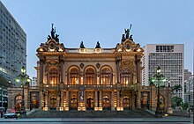

São Paulo is considered a cultural center in Brazil, having consolidated itself as the place of origin of a whole series of artistic and esthetic movements throughout the history of the twentieth century. In spite of the fact that the status of the country's main cultural institutions has traditionally been rivaled with Rio de Janeiro, it is in São Paulo that there is the largest market for culture, having today consolidated itself as one of the main cultural capitals of Brazil and Latin America.
The culture of the city of São Paulo was largely influenced by the various groups of immigrants that established themselves there, mainly Italians. São Paulo has a wide network of theaters, show and show houses, bars and major cultural events such as the São Paulo Biennial, the Cultural Turn and the São Paulo Jazz Festival. Educational institutions, museums and art galleries often employ superlatives in their descriptions (for example, it is the largest public university in the country — the University of São Paulo — the largest private university — the Paulista University — and the largest house of spectacles in the country, Credicard Hall).
Among the city's most famous museums are the São Paulo Art Museum (MASP), the Ipiranga Museum, the Sacra Art Museum, the Portuguese Language Museum, the São Paulo State Art Museum, among other renowned institutions. It also houses one of the five largest zoos in the world, the São Paulo Zoo Park.
Literature
Literature in the city of São Paulo begins with the arrival of missionaries from the Company of Jesus, whose members are known as Jesuits, at the beginning of the sixteenth century. The Jesuit priests Manuel da Nóbrega and José de Anchieta are considered the founders of the São Paulo capital.
During the 19th century the city had great names of literature such as the writer Álvares de Azevedo, representative of the ultra-romantic phase of romanticism. However, São Paulo writers only achieved cultural independence and national projection at the beginning of the twentieth century, with the Brazilian modernist movement, mainly after the Week of Modern Art was held in 1922. During this time important writers of Brazilian literature such as Mário de Andrade and Oswald de Andrade appeared, responsible for the introduction of modernism in the country and producers of an extensive and important literary, dramatic and critical work for Brazilian culture.
Music
The city has renowned names such as Adoniran Barbosa, whose most remembered successes are Saudosa Maloca and Trem das Eleven, and the Demons of Garoa, a samba group from the 1940s still in activity considered the "Oldest Vocal Set of Brazil in Activity". The municipality was also the birthplace of various rock bands in the 1960s, 1970s and 1980s, such as The Mutantes, Ultraje a Rigor and the Titans.
Among the contemporary São Paulo singers of greatest recognition are artists such as Ana Cañas, Criolo, Emicida, Maria Gadú, Maria Rita, Mallu Magalhães, Marcelo Jeneci, Raciones MC's, Tiê, among others. São Paulo is also one of the main classical music centers in Brazil, being the birthplace of internationally recognized composers such as Osvaldo Lacerda and Amaral Vieira, and the stage during the whole year of concert and opera performances in their various rooms, such as the Sala São Paulo, the Municipal Theater of São Paulo, the São Pedro Theater and the Alfa Theater. The São Paulo State Symphony Orchestra (Osesp) is considered the best symphony group in Latin America.
Media
São Paulo is one of the main communication centers in Brazil and Latin America, since it brings together in its territory the headquarters of several large communication groups. Two of the country's most influential newspapers are published in the city, both with an international reputation: Folha de S.Paulo and O Estado de S. Paulo (the oldest newspaper in the city still in circulation).
In the field of television, the city was a pioneer with the creation of the country's first broadcaster, TV Tupi, by businessman Assis Chateaubriand, in September 1950. The city was also a pioneer in advertising, with the first advertising agency in the country, called "The Eclética", installed in it in 1914. Currently, the municipality is a major national and international advertising center. São Paulo also concentrates a large number of publishers that produce some of the main publications in Brazil. Among them is the April Group.
Sports
Allianz Parque, the arena of the Palmeiras Sports Society | Arena Corinthians, one of the 2014 World Cup and 2016 Olympic Games |
The city is home to sporting events of national and international importance, such as the Brazil Formula 1 Grand Prize, held at the Interlagos automobile, the São Paulo Indy 300, an event that is part of the IndyCar Series and is held in the Anhembi Circuit, and the São Paulo Tennis Open, held in the Villa-Lobos Park Tennis Complex.
The traditional São Silvestre Race is also taking place in the city. Among the main events in which São Paulo was headquartered are the 1950 FIFA World Cup, the 1963 Pan American Games and the 2000 Interclubs World Cup, as well as being the host city that received the 2014 FIFA World Cup (and five more matches from the same tournament). The city also has a Jockey Club, where the first race took place on October 29, 1876.
The municipality is the headquarters of three major Brazilian football clubs: Palm trees, Corinthians, and São Paulo. In addition to the so-called "Trio de Ferro", it also has other football associations, such as the Portuguese, Juventus, the National and Barcelona football clubs.
2012 San Silvestre International Race, one of the oldest in South America | Autodrome de Interlagos during the 2015 Brazilian Formula 1 Grand Prize |
Besides the current clubs, São Paulo had several historical clubs in the "Amateur Era of Football Paulista" that conquered the São Paulo Football Championship at the beginning of the 20th century, making the most of São Paulo Athletic, the first São Paulo champion and the only Brazilian club through which Charles Miller played soccer to Brazil, Paulistan and AA of the Palm Trees that his dissidents would join together to form São Paulo FC, the Germania that was obliged to change its name during World War II and went on to be called Sports Club Pinheiros, which up until today is an important club in the city, the American, International and São Bento complete the historical clubs of São Paulo that conquered the São Paulo Championship.
The city has five large stadiums: Morumbi from São Paulo FC; Pacaembu, municipal government; the arena Allianz Parque da S.E. palm trees; Canindé Stadium, a Portuguese sports stadium and the Arena do Corinthians, of Sport Club Corinthians Paulista, located in Itaquera, in the eastern part of the city, with a planned capacity of 48,000 people. It also has several volleyball and basketball gymnasiums, tennis courts, and many other sports arenas, such as Ibirapuera's Stadium, intended mainly for athleticism.
See also
- São Paulo Stock Exchange
- Center of São Paulo
- Historical Center of São Paulo
- Global cities
- Expanded Metropolitan Complex
- Favelas in the city of São Paulo
- Marco zero of the city of São Paulo
- Megalopole Rio-São Paulo
- Christmas in the city of São Paulo
- Parks in the city of São Paulo
- São Paulo City Paulistas
- Metropolitan Region of São Paulo
Lists
- List of the world's most populous cities
- List of skyscrapers in the city of São Paulo
- List of Brazilian Capital by HDI
- List of cities by GDP
- List of municipalities in São Paulo by IDH
- List of municipalities in São Paulo by population
- List of São Paulo subprefectures by Human Development Index
- List of the hundred most populous municipalities in Brazil (2010)
- List of districts of São Paulo by Human Development Index
- List of municipalities in São Paulo by area
- Subprefectures in the municipality of São Paulo
References
- ↑ to b Brazilian Institute of Geography and Statistics (IBGE) (2017). "Database by municipalities of Immediate and Intermediate Geographical Regions of Brazil". having been consulted on 10 February 2018
- ↑ Geographic Atlas of Brazil. "State capital". Referred to on 1 January 2011. Copy archived February 2, 2018
- ↑ Geosampa. "The Consultation System of the Digital Map of the City of São Paulo". City hall. having been consulted on 2 February 2018
- ↑ to b Institute of Astronomy, Geophysics and Atmospheric Sciences of the University of São Paulo (IAG). "IAG/USP Meteorological Station". University of São Paulo (USP). Consulted on 5 February 2017. Original Archived February 2, 2018
- ↑ to b cd Brazilian Institute of Geography and Statistics (IBGE). "São Paulo". Consulted on 6 October 2019. Copy archived on October 6, 2019
- ↑ to b Brazilian Agricultural Research Corporation (EMBRAPA). "Urban areas in Brazil in 2015". having been consulted on 27 July 2020
- ↑ to b EMBRAPA (2000) "São Paulo". Consulted on 23 August 2011. Copy archived on August 23, 2011
- ↑ to bc United Nations Development Program (UNDP) (29 July 2013). "Rating of IDH-M from Brazil's Municipalities" (PDF). Atlas of Human Development of Brazil. Consulted on 31 July 2013. Archived Copy (PDF) July 8, 2014
- ↑ to b IBGE (2016) "Gross Domestic Product of Municipalities - Year 2016". having been consulted on 2 April 2019
- ↑ to b Pimenta, Angela (2 November 2007). "Forget the countries. Power is with cities." Review Magazine. Original Archived March 22, 2009
- ↑ to bc Brazilian Institute of Geography and Statistics (IBGE) (August 29, 2018). "Estimates of the population resident in Brazilian municipalities with a reference date July 1, 2018" (PDF). Consulted on 29 August 2018. Copy archived on August 29, 2018
- ↑ GaWC, Univ. Loughborough. "Inventory of World Cities"
- ↑ "Brasão & Divisa da Cidade de São Paulo". Consulted on 27 April 2018. Original Archived October 27, 2011
- ↑ to b "São Paulo will be the sixth richest city in the world by 2025, says ranking". Price Waterhouse & Coopers and BBC Brasil 8 November 2009. having been consulted on 8 November 2009
- ↑ "At the age of 464, São Paulo has a sounder economy in the country". FecomercioSP. January 22, 2018. having been consulted on 30 May 2019
- ↑ "City of the World." Bureau of International Relations of São Paulo. Consulted on 4 May 2011. Original Archived January 7, 2012
- ↑ to b "Communications and Press Adviser." State University of Campinas (Unicamp). 17 June 2005. Consulted on 8 September 2008. Original Archived June 17, 2008
- ↑ to b "Redefining Global Cities" (PDF). Global Cities Initiative. 2016. having been consulted on 10 December 2016
- ↑ to b "Merger between BM&FBovespa and Cetip creates the world's fifth largest stock exchange." Agência Brasil. 30 March 2017. Consulted on 27 April 2018. Copy archived April 27, 2018
- ↑ "Table 793 - Resident population, April 1, 2007: Full Publication’. IBGE Automatic Recovery System (SIDRA). 14 November 2007. having been consulted on 10 August 2008
- ↑ to b "World Gazetteer - Welt: Ballungsräume". having been consulted on 10 August 2008
- ↑ to b "The 10 smallest foreign communities in São Paulo". The State of S. Paul. October 24, 2016. having been consulted on 24 October 2016
- ↑ to b S.A., São Paulo Metropolitan Planning Company. "Macrometropolis Paulista". EMPLASA
- ↑ "The first macrometropolis of the southern hemisphere". 3 August 2008 Original Archived March 27, 2014
- ↑ "The São Paulo Macrometropolis now comprises 153 cities and 30 million people". The Globe. having been consulted on 5 April 2014
- ↑ to bc AZEVEDO MARQUES, Manuel Eufrásio, Province of São Paulo, Editora Itatiaia, 1980
- ↑ SampaArt (ed.) "The Way to Father José de Anchieta". Consulted on 12 March 2012. Original Archived December 5, 2007
- ↑ to b San Francisco Portal (ed.). "History of the city of São Paulo - Foundation". Consulted on 12 March 2012. Archived from original on March 22, 2012
- ↑ "The Origins of the City: Patio do Colegio Sao Paulo". São Paulo Info. Consulted on 10 September 2011. Copy archived on March 22, 2012
- ↑ PEREZ, Sandra. St André: the invention of the city. Master's dissertation. USP: São Paulo, 2010.
- ↑ Luís Indriunas HowStuffWorks, ed. "How São Paulo arose and grew.'' Consulted on 12 March 2012. Archived from original on March 22, 2012
- ↑ PRESTES DE ALBUQUERQUE, Júlio, In The Ranch of Paranapiacabre, Casa Mayença, São Paulo, 1922
- ↑ das Neves, Cylaine Maria (2007). The village of São Paulo in Piratininga: foundation and representation. São Paulo: Annablume. p. 18 ISBN 8574197793. having been consulted on 12 March 2012
- ↑ Amilcar Torrão Filho (October 2007) FAPESP, ed. "Chaos Paradigm or Conversion City?". having been consulted on 20 September 2015
- ↑ ELLIS JÚNIOR, Alfredo, The São Paulo Bandeirismo and the Indent of the Meridiano, Companhia Editora Nacional [National Editora Company], São Paulo, 1934.
- ↑ Danilo Ribeiro Gallucci. Almanac Brasil, ed. "The first paved road brings São Paulo closer to Santos". Consulted on 12 March 2012. Copy archived on March 22, 2012
- ↑ "Imperial City and Bourg of Students (1822-1889)". PRODAM/SP. Consulted on 31 December 2017. Copy archived on March 22, 2012
- ↑ to b cd Paula Porto, Antonio Arnoni Prado, Alzira Campos, Adriano Luiz Duarte (2004). "History of the city of São Paulo: The city in the Empire, 1823-1889." having been consulted on 12 March 2012
- ↑ to b cd City Hall of São Paulo, ed. (5 October 2005) "Opening the tracks for the locomotive". Consulted on 12 March 2012. Archived from original on March 22, 2012
- ↑ PIRES, Cornélio, Samba and Cateretês, Editora Unitas Ltda, São Paulo, 1932
- ↑ Toledo, 2004
- ↑ Jéssika Torrezan (29 June 2011). See, ed. "The Jardins story." Consulted on 12 March 2012. Archived from original on March 22, 2012
- ↑ "Revolution of 1924." São Paulo State Public Archive
- ↑ Lima, Erly (2013). SARA Brasil's Pioneering Survey: History, technology employed and product assessment (MSc). University of São Paulo. doi:10.11606/d.3.2012.tde-26072013-142950
- ↑ Tourism (4 March 2010). "History of São Paulo". Referred to on 3 January 2011. Copy archived March 30, 2012
- ↑ Baty, Phil. "The goals will eat." Times Higher Education. having been consulted on 30 October 2010
- ↑ to bc São Paulo is 450 years old (ed.). "Modern City (1930-1960)". Consulted on 28 March 2012. Original Archived March 30, 2012
- ↑ PRESTES MAIA, Francisco, Avenue Plan for the City of São Paulo, Editora Improvements, São Paulo, 1930
- ↑ The state helps the city hall solve the city's crucial problem: the subway, Diário Oficial do Estado de São Paulo, page 1, February 14, 1963
- ↑ "Company_Who We Are". São Paulo subway. 2016. Consulted on 27 April 2018. Copy archived April 27, 2018
- ↑ "São Paulo ranks 56th in global trade ranking". BBC Brasil 9 June 2008. Consulted on 13 October 2008. Archived from original on March 22, 2012
- ↑ City of São Paulo (November 3, 2010). "Jaraguá Peak". having been consulted on 5 March 2011
- ↑ "The largest urban forest in the world." White Stone State Park. Consulted on 22 November 2008. Archived from original on July 15, 2011
- ↑ Gabriela Taussig Fujita (March 2005) "Water for ecosystems". Earth Magazine. having been consulted on 22 November 2008
- ↑ IBGE. "Gross Domestic Product of Municipalities 2005-2009" (PDF). Consulted on 31 January 2012. Original Archive (PDF) August 5, 2012
- ↑ "Britannica Online Encyclopedia - Climate of São Paulo". Encyclopæ Britannica day. having been consulted on 23 July 2020. Copy archived 19 September 2010
- ↑ R7.com (16 December 2018) "The city of São Paulo is in a state of attention for floods.'' having been consulted on 23 July 2020. Copy archived July 30, 2020
- ↑ Pedro Prata (25 February 2020) "Rain leaves SP in a state of alert for flooding." UOL. having been consulted on 23 July 2020. Copy archived July 30, 2020
- ↑ "Heat causes rain clouds over Greater São Paulo". São Paulo City Hall. 17 March 2020. Consulted on 24 July 2020. Copy archived July 30, 2020
- ↑ to bc National Meteorological Institute (INMET) (1979). "Climatological Norms of Brazil (1931-1960)" 2 ed. Rio de Janeiro. having been consulted on 21 July 2020
- ↑ to b cd INMET "Station: SÃO PAULO (MIR.de SANTANA) (83781)". having been consulted on 12 October 2020
- ↑ INMET (1 July 2020). "SÃO PAULO CAPITAL, JUNE 2020 BALANCE SHEET" (PDF). Consulted on 20 July 2020. Archived Copy (PDF) July 3, 2020
- ↑ "Winter begins with dry time." São Paulo City Hall. 20 June 2008. having been consulted on 23 July 2020. Copy archived July 30, 2020
- ↑ Vivian Reis (16 July 2018). "SP registers 18% of relative humidity of the air and goes into a state of alert". G1. having been consulted on 23 July 2020. Copy archived July 30, 2020
- ↑ "São Paulo has had the driest April of the last 21 years". G1 30 April 2016. having been consulted on 23 July 2020. Copy archived July 30, 2020
- ↑ PEGORIM, Josélia (8 July 2019). "Crio achieved a record 8 years in the interior of SP". Climate. having been consulted on 24 July 2020
- ↑ MAIA, Dhiego (4 July 2019). "The first wave of cold arrives at the SP and knocks down temperatures, causes rain and floods the streets". Folha de S.Paulo. having been consulted on 24 July 2020
- ↑ "São Paulo records the coldest day in 52 years, says Inmet". G1 July 24, 2013. having been consulted on 13 October 2020
- ↑ Jornal Nacional (5 June 2015). "Dense fog leaves the city of São Paulo unrecognizable". G1. having been consulted on 23 July 2020. Copy archived July 30, 2020
- ↑ Eugenio Hackbart (5 June 2007). "A cold wave guarantees rare images of frost inside the city of São Paulo". METSUL. Consulted on 24 March 2014. Original Archived March 7, 2016
- ↑ to bc INMET "Meteorological database". having been consulted on 12 October 2020
- ↑ to b INMET "Station: SÃO PAULO - MIRANTE (A701)". having been consulted on 12 October 2020
- ↑ INMET "CLIMATOLOGICAL STANDARDS OF BRAZIL". having been consulted on 12 October 2020
- ↑ NONATO, Viviane Samara Barbosa (8 October 2020). "SÃO PAULO CAPITAL REGISTERS THE 3RD LARGEST TEMPERATURE IN 77 YEARS". INMET. having been consulted on 12 October 2020. Copy archived October 13, 2020
- ↑ Charles Ayoub "São Paulo". Consulted on 23 May 2015. Original Archived February 1, 2014
- ↑ "SP article }". Pt.scribd.com. having been consulted on 22 July 2014
- ↑ Leonel, Cristiane (June 2009). "Cantareira State Park Management Plan: Executive Summary" (PDF). SEMA/SP. p. see. Consulted on 10 December 2016. Original Archive (PDF) March 12, 2016
- ↑ Simon Romero (16 February 2015). Taps Start to Run Dry in Brazil's Largest City. New York Times. having been consulted on 18 February 2015
- ↑ "Odor of the Pinheiros River, in SP, can cause sickness and headache", Folha de S.Paulo, April 8, 2012
- ↑ School of Public Health, University of São Paulo (2003). "Air pollution and children's health in São Paulo (1986-1998)". Soc Sci Med. 53 (Dec): 2013-2022. having been consulted on 6 May 2006
- ↑ See, ed. (26 September 2011) "Rio has more polluted air than Cubatão and São Paulo, says OMS". having been consulted on 27 September 2013
- ↑ G1, ed. (24 September 2013) "Study indicates that pollution kills more than traffic in São Paulo.'' having been consulted on 27 September 2013
- ↑ The State of S. Paul, ed. (22 September 2013) "The country's most polluted river, Tietê is also the richest and most populous". having been consulted on 27 September 2013
- ↑ Leticia Mori (4 December 2017). BBC Brasil, ed. "Why has São Paulo not yet managed to clean up the river Tietê?". having been consulted on 29 December 2017
- ↑ Whately, Marussia; Blauth, Fernanda; Weiss, Bruno; "Will there be water for everyone?" in Le Monde Diplomatique Brasil, edition of January 2008; São Paulo: Instituto Pólis
- ↑ "Cars of R$ 6,000 would anticipate blackout in traffic". News, Terra. 22 September 2007. having been consulted on 10 September 2011
- ↑ Municipal parks. City Hall of São Paulo. Consulted on 20 March 2010. Archived from original on July 25, 2010
- ↑ Cantareira State Park. Government of the State of São Paulo. having been consulted on 18 September 2010
- ↑ "Needy Paulistans of green areas." Echo. January 22, 2009. Consulted on 27 June 2009. Copy archived March 7, 2016
- ↑ People's Gazette, ed. (23 March 2016) "One tree per inhabitant, the WHO's minimum recommendation for cities". having been consulted on 27 April 2018
- ↑ "3rd Green Area Seminar" (PDF). São Paulo City Hall. November 2010. p. 98. Consulted on 28 April 2018. Archived Copy (PDF) April 28, 2018
- ↑ "Raul Seixas Park turns 20, with a lot of party." São Paulo City Hall. 8 October 2009. Consulted on 28 April 2018. Copy archived April 28, 2018
- ↑ City Hall of São Paulo, ed. (2002) Environmental Atlas. having been consulted on 11 October 2014
- ↑ Edison Veiga (30 August 2014). The State of S. Paul, ed. "The one that doesn't come out of fashion". Consulted on 31 August 2014. Archived from original on September 1, 2014
- ↑ to b "Table 1287 - Population of the capitals and Percentage of the population of the capitals compared to the federation units in the Demographic Census". IBGE. having been consulted on 24 November 2008
- ↑ "The Brazilian capitals that have grown the most in the last century". 30 May 2013. having been consulted on 21 June 2015
- ↑ "São Paulo once and now" (PDF). State Data Analysis System Foundation. 2004. having been consulted on 21 June 2015
- ↑ IBGE (2010) "Table 2.1 - Resident, total, urban total and urban population at the municipal headquarters, in absolute and relative numbers, with indication of total area and population density according to the Federation Units and municipalities 2010". having been consulted on 10 September 2011
- ↑ IBGE (2010) "Table 608 - Resident population by home and sex status - Synopsis". having been consulted on 18 June 2015
- ↑ IBGE (2010) "Table 761 - Resident population, by home situation, with indication of the urban population resident at the municipal headquarters - Sinopse". having been consulted on 18 June 2015
- ↑ to bc São Paulo city (ed.). "Work and Development Atlas of the City of São Paulo". having been consulted on 28 March 2012
- ↑ to b Eunice Ribeiro Durham (April 1986). "The Viewed Society of the Outskirts." having been consulted on 29 March 2012
- ↑ Villaça, 1998; Maricato, 1996; Rolnik, 2003
- ↑ BBC/G1. (26 May 2010) São Paulo ranks 117th in the world quality of life ranking, access on May 26, 2010
- ↑ BBC/O Estado de S. Paul. (May 26, 2010).São Paulo ranks 117th on quality of life, access on May 26, 2010
- ↑ "São Paulo, SP." Atlas of Human Development in Brazil. having been consulted on 21 June 2015
- ↑ "Brasile, la stella del Sud". Archivio Storico dell'Emigrazione Italiana. 11 December 2007. having been consulted on 20 November 2008
- ↑ "Northeast are the victims of prejudice." Sheet Online. having been consulted on 20 November 2008
- ↑ "Table 2093 - Population resident by color or race, sex, home situation and age groups - Sample - General Population Characteristics". IBGE. 2010. having been consulted on 1 April 2012
- ↑ to b "The capital of São Paulo has an Italian accent". Agência Brasil. Consulted on 10 September 2011. Original Archived June 23, 2008
- ↑ "The Metropolis." City Hall of São Paulo. Consulted on 22 November 2008. Archived from original on July 14, 2012
- ↑ "São Paulo consumes more pizza than Italy". JB Online. 27 August 2007. having been consulted on 20 November 2008
- ↑ "Consumption of pizzas in the capital of São Paulo only loses to New York.'' UOL News. 10 July 2008. Consulted on 20 November 2008. Original Archived October 5, 2009
- ↑ "More than three million Portuguese live in the city". Agência Brasil. Consulted on 22 November 2008. Original Archived April 7, 2010
- ↑ to b Fernanda Pereira Neves and Matheus Magenta (25 January 2009) Folha de S.Paulo, ed. "Asians and South Americans are the main people who emigrate to São Paulo". having been consulted on 28 March 2012
- ↑ to b Monia Ferrari/UFSCar "The Northeast Migration to São Paulo in the second Vargas government (1951-1954) - Drought and regional inequalities". having been consulted on 4 September 2011
- ↑ Migrants. Government of the State of São Paulo. having been consulted on 24 November 2008
- ↑ SEADE, ed. (2006) "the largest black population in the country" (PDF). p. 3. Consulted on 28 March 2012. Original Archive (PDF) October 14, 2013
- ↑ Giving Brazil a taste of Arabia. BBC. having been consulted on 22 November 2008
- ↑ "Arabs find peace and prosperity in São Paulo." Agência Brasil. Consulted on 24 November 2008. Original Archived November 2, 2008
- ↑ "São Paulo - Four and a half centuries." Agência Brasil. Consulted on 10 September 2011. Original Archived June 29, 2008
- ↑ "Almost Half The Brazilian Netizens With Gay Marriage". Ibope. March 25, 2013. Original Archived June 20, 2014
- ↑ "Revelers Take To The Streets For 48th Annual NYC Pride March". CBS New York. 25 June 2017. Consulted on 26 June 2017.
A sea of queen bows over the Big Apple for the main star in the world Sunday.
- ↑ villagevoice.com (15 April 2012). Grindr Awards For Gayest Cities, Beaches, And Marital Destinations. Consulted on 15 October 2019. Original Archived April 15, 2012
- ↑ to b cd IBGE (2010) "Table 2094 — Population resident by color or race and religion". having been consulted on 18 June 2015
- ↑ Gilberto Batista Castilho and Marília Gomes Ghizzi Godoy (April 2006). São Marcos University, ed. "The presence of oriental values in Brazilian culture: new Japanese religions" (PDF). having been consulted on 29 March 2012
- ↑ "Archdiocese of São Paulo". having been consulted on 28 March 2012
- ↑ Lívia Marra (1 October 2002). "Reopened, Cathedral of the Seat (SP) has daily mass and guided visits". Folha de S.Paulo. having been consulted on 24 November 2008
- ↑ Song New, ed. (24 January 2008) "Apostolo Paulo is the city's new baker." having been consulted on 28 March 2012
- ↑ São Paulo city (ed.). "Penha subprefecture - History". Consulted on 28 March 2012. Original Archived November 26, 2016
- ↑ "Map of Violence of Brazilian Municipalities 2008" (PDF). The Globe. January 29, 2008. Consulted on 29 April 2018. Archived Copy (PDF) April 29, 2018
- ↑ Angela Pinho (30 January 2008) "The number of murders falls in Brazil". Sheet Online. Consulted on 14 February 2008. Copy archived April 17, 2018
- ↑ "SP is capital with fewer young people exposed to violence, says research". G1 24 November 2009. Consulted on 25 November 2009. Copy archived January 27, 2016
- ↑ "In 10 years, new profile of crime in SP." The State of S. Paul. 13 February 2011. Consulted on 15 February 2011. Original Archived February 16, 2011
- ↑ Review Magazine, ed. (6 October 2011) "Reducing the murder rate in SP is surprising to the United Nations". having been consulted on 11 October 2010
- ↑ Isabela Viera (13 December 2012). "The murder rate of young people grows by 14% from 2009 to 2010." EBC. Consulted on 29 April 2018. Copy archived April 29, 2018
- ↑ WAISELFISZ, Julio Jacobo (2011). "2011 Violence Map" (PDF). Sangari Institute. Consulted on 5 March 2011. Original Archive (PDF) February 27, 2017
- ↑ "Crime goes up in Greater São Paulo in April, indicates balance". Magazine See. May 26, 2017. Consulted on 29 April 2018. Copy archived 12 October 2017
- ↑ Lessandro Vendrame and Kerma Matos (1 March 2007). "Serra and Marzagão visit 9th DP, one of the top five in the world." Secretary of Public Security — Government of the State of São Paulo. Consulted on 18 September 2010. Original Archived March 3, 2016
- ↑ São Paulo city (ed.). "São Paulo, from taipa to concrete". Consulted on 29 March 2012. Original Archived May 22, 2016
- ↑ to b cd Municipal Secretariat for the Coordination of the Subprefectures. "What is." Municipal Secretariat for the Coordination of Subprefectures. Consulted on 18 September 2010. Archived from original on July 27, 2016
- ↑ "CONSTITUTIONAL AMENDMENT NO 58 OF 23 SEPTEMBER 2009". Federal Senate. having been consulted on 24 November 2008
- ↑ São Paulo city (ed.). "LDO - Budget Guidelines Act". having been consulted on 29 March 2012
- ↑ São Paulo Tourism. "About São Paulo Tourism". Consulted on 18 September 2010. Archived of the original on December 27, 2010
- ↑ NATIONAL PUBLIC TRANSPORT ASSOCIATION. "CIA. TRAFFIC ENGINEERING - CET/SP". Consulted on 18 September 2010. Original Archived October 11, 2010
- ↑ São Paulo City Hall. "History". Consulted on 18 September 2010. Original Archived June 22, 2013
- ↑ São Paulo City Hall. "Company". Consulted on 18 September 2010. Original Archived May 26, 2010
- ↑ São Paulo City Hall. "Company". having been consulted on 31 December 2017
- ↑ "The SPTrans". Consulted on 18 September 2010. Original Archived October 7, 2015
- ↑ SÃO PAULO, Law ⠀ 14.471 of 10.7.2007. Consolidates municipal legislation on sister cities in the city of São Paulo, and provides other measures.
- ↑ SÃO PAULO, Decree ⠀ No 58.938 of 2.9.2019. It declares "Sister Cities" São Paulo and Belmonte.
- ↑ SÃO PAULO, Decree ⠀ No 26.122 of 8.6.1988. It declares "Sister Cities" Miami and São Paulo.
- ↑ Citizen Observatory - Rede Nossa São Paulo (Our São Paulo Network), this site analyzes the 31 subprefectures and the 96 districts[inative link]
- ↑ "LAW NO 13.399 OF 1 AUGUST 2002 - HAS AVAILABLE ON THE CREATION OF SUBPREFECTURES IN THE MUNICIPALITY OF SÃO PAULO, AND GIVES OTHER PROVIDENCE" (PDF). São Paulo City Hall Portal. Consulted on 19 June 2012. Archived Copy (PDF) September 14, 2012
- ↑ "LAW NO 11,220 OF 20 MAY 1992 - ESTABLISHES THE GEOGRAPHICAL DIVISION OF THE AREA OF THE MUNICIPALITY IN DISTRICTS, REPEALS LAW NO 10,932 OF 15 JANUARY 1991 AND GIVES OTHERS PROVISIONS. Consulted on 19 June 2012. Original Archived December 8, 2012
- ↑ "Streets in São Paulo are getting new identification signs". City Hall of São Paulo. Consulted on 18 September 2010. Original Archived June 7, 2007
- ↑ Municipal Secretariat for the Coordination of the Subprefectures. "Demographic Data of the Districts belonging to the Subprefectures". Municipal Secretariat for the Coordination of Subprefectures. Consulted on 27 September 2010. Copy archived September 14, 2012
- ↑ "Economic activities of Brazil by employees (2012)". DataViva Platform. Consulted on 13 January 2014. Original Archived January 16, 2014
- ↑ "São Paulo completes 465 years ahead of the country's economic growth". FecomercioSP. January 18, 2019. having been consulted on 30 May 2019
- ↑ IBGE. "Gross Domestic Product of Municipalities 2014". having been consulted on 4 February 2017
- ↑ The State of S. Paul, ed. (24 January 2013) "The city of São Paulo generates R$ 14,000 in wealth per second". having been consulted on 25 January 2013
- ↑ "IBGE: half of the GDP of SP is in the metropolitan region". Newspaper "The State." 20 December 2007. Consulted on 24 November 2008. Original Archived November 10, 2008
- ↑ "IBGE discloses a list of the 12 most influential cities in the country". G1 10 October 2008. having been consulted on 21 March 2010
- ↑ Patricia Lara (21 May 2011). "SP is the sixth city in the world in number of billionaires". State Agency. having been consulted on 10 September 2011
- ↑ The global crisis affected more SP, says FGV, O Estado de S. Paul, October 9, 2009.
- ↑ "Worldwide Cost of Living survey 2011 - Top 50 Cities: Cost of living ranking. Mercer. 12 July 2011. having been consulted on 22 July 2011
- ↑ "SP is the 10th most expensive city in the world for foreigners; RJ is the 12th." UOL News. 12 July 2011. having been consulted on 22 July 2011
- ↑ to b Ricardo Gallo. "Incomplete, Oscar Freire opens his new face." having been consulted on 26 December 2007
- ↑ "American Cities of the Future 2013/14"
- ↑ "Ranking places São Paulo as the second city of the future in America". Original Archived February 18, 2016
- ↑ Heitor Frúgoli Jr. "Centrality in São Paulo: trajectories, conflicts and negotiations in the metropolis." São Paulo 450 Years Old. Consulted on 15 December 2010. Original Archived July 6, 2011
- ↑ "Trends in social segregation in global and unequal metropolises: Paris and Rio de Janeiro in the 1980s". Eure (Santiago). having been consulted on 24 November 2008
- ↑ Zeuler Lima. "Global barriers in São Paulo: urbanization without urbanism?" Vitruvius gate. having been consulted on 17 February 2008
- ↑ Ferreira, João Sette Whitaker; The myth of the global city, doctoral thesis presented to FAUUSP, 2003; Fix, Mariana; São Paulo: global city; São Paulo: Boitempo, 2007
- ↑ "Study on the informal economy in São Paulo". Institute for Labor and Society Studies (IETS). Consulted on 17 February 2008. Original Archived March 16, 2008
- ↑ "Profile of young poor people in São Paulo reveals an increase in schooling". Sheet Online. 23 August 2001. having been consulted on 22 November 2008
- ↑ Marcelo Mora (10 July 2008) "March 25' is the center for the irradiation of piracy, says delegate.'' G1. having been consulted on 10 September 2011
- ↑ Priscila Trindade (16 December 2009). "City Hall does an operation against piracy in São Paulo". State Agency. having been consulted on 10 September 2011
- ↑ "City Hall destroys 1.5 million pirated and smuggled CDs and DVDs." Municipal Council of São Paulo (SP). 18 December 2007. Consulted on 10 September 2011. Original Archived June 7, 2009
- ↑ to b São Paulo Tourism S/A (SP Turs) (ed.) "The best destination for your events and business". having been consulted on 29 March 2012
- ↑ Carol Garcia. "São Paulo Fashion Week and the expansion of value added to the participating brands". Brazil fashion. having been consulted on 20 November 2008
- ↑ Folha de S.Paulo, ed. (24 June 2011) "Gay stop is an event that attracts more tourists to SP, says SPTuris". having been consulted on 3 July 2015
- ↑ "São Paulo is among the 25 most expensive cities in the world". RFI. 24 July 2008. having been consulted on 22 November 2008
- ↑ "Paris ties with Vienna as top conference city in ICCA rankings". May 2009. having been consulted on 1 June 2009
- ↑ BBC Brasil, ed. (11 July 2014) "SP can become the main tourist destination at AL in 2017, the study points out". having been consulted on 12 July 2014
- ↑ Yahoo! News, ed. (29 September 2014) "The 10 best cities in the world to go out at night (there is Brazilian on the list)". having been consulted on 1 October 2014
- ↑ "Retrospective." International Congress of Gastronomy, Hospitality and Tourism. Consulted on 21 March 2010. Original Archived March 26, 2010
- ↑ "Coverage of international newspapers reveals São Paulo to the world". March 2013. having been consulted on 29 March 2013
- ↑ to b cd ‘Municipality in Data: Infrastructure". Consulted on 17 December 2007. Archived from the original on January 15, 2008 São Paulo City Hall
- ↑ to b "Water supply and sanitary exhaustion in Brazilian Capital, 2004" (PDF). Consulted on 5 February 2008. Original Archive (PDF) July 23, 2008
- ↑ to b The State of S. Paulo (May 14, 2010). "Urban sustainability". Consulted on 14 May 2010. Copy archived 6 July 2011
- ↑ Skyline Ranking. Emporis.com. having been consulted on 20 November 2008
- ↑ Sylvio Rocha Nogueira. "The vertical development of the land and the best Brazilian urbanism". Magazine YES. Consulted on 22 November 2008. Original Archived July 7, 2009
- ↑ Portal Terra, ed. (20 November 2000) "Banespa Headquarters becomes Spanish". having been consulted on 4 October 2014
- ↑ Heitor and Silvia Reali. Martinelli building. Andreato Communication and Culture. having been consulted on 10 September 2011
- ↑ to b c dand Luís Indriunas HowStuffWorks, ed. "Urban planning in São Paulo". Consulted on 29 March 2012. Archived of the original on December 21, 2016
- ↑ Cf. Feldman, 2005 and Villaça, 2001
- ↑ Rolnik, 2007; Maricato, 2003 ([1])
- ↑ Maricato, op. cit.
- ↑ "The Housing Deficit and the Invasion of the Prestes Maia Building." São Paulo City Hall. 26 February 2006. having been consulted on 22 November 2008
- ↑ Idem, Excerpt: (..)3.4 million live in precarious housing, 1.6 million in clandestine or irregular building lots, 1.2 million in slums and 600,000 in slum.
- ↑ Luiza Bragion. "Housing deficit requires urgent measures". Science. Consulted on 20 November 2008. Original Archived June 21, 2013
- ↑ Metropolis. The State of S. Paul. 23 November 2006. Consulted on 20 November 2008. Original Archived July 1, 2014
- ↑ "São Paulo has a fall in population growth". Terra News. 24 November 2008. having been consulted on 24 November 2008
- ↑ "Paulista and Masp: most sought-after destination by tourists". See São Paulo
- ↑ to b cd Marisa Varanda Teixeira Carpenter (2007). Institute of Philosophy and Human Sciences (IFCH) of the State University of Campinas (UNICAMP), ed. "Time and History on the Avenue Plan." having been consulted on 29 March 2012
- ↑ Feldman, Sarah; Planning and zoning: São Paulo 1947-1972; São Paulo: Edusp, 2002, ISBN 8531408482
- ↑ Feldman, 2004. Op. cit.; Villaça, 1998, op. cit.
- ↑ Albert Einstein Hospital (ed.). "Einstein ranked first in the ranking of Latin America's best hospitals." Consulted on 6 November 2012. Original Archived October 3, 2013
- ↑ Hospital News (ed.). "Management of the complex: The Hospital das Clínicas of São Paulo, the largest hospital complex in Latin America, is looking for new ways to improve its management". having been consulted on 6 November 2012
- ↑ Folha de S.Paulo, ed. (7 May 2008) "The new cancer institute will attend to health plans.'' having been consulted on 6 November 2012
- ↑ to b Datasus. DATASUS. Datasus.gov.br. having been consulted on 6 November 2012
- ↑ "São Paulo em Movimento - Fleet of municipal bus lines". City Hall of São Paulo. Consulted on 21 March 2010. Archived of the original on December 19, 2014
- ↑ "Prefect delivers regular certificates to charterers". APPROVE. Consulted on 24 November 2008. Original Archived July 6, 2011
- ↑ "São Paulo should today reach the mark of 6 million vehicles". Sheet Online. 21 February 2008. having been consulted on 20 November 2008
- ↑ Metropolis Numbers. SPMepole. Consulted on 1 May 2010. Original Archived February 28, 2010
- ↑ Carolina Garcia (19 August 2013). "São Paulo now has the largest fleet of helicopters in the world and adopts restrictions". IG. having been consulted on 27 September 2013
- ↑ "The second phase of the Wheel should reduce the traffic of trucks on the fringe". having been consulted on 31 January 2011
- ↑ "São Paulo". Government of the State of São Paulo. Consulted on 20 March 2010. Original Archived July 6, 2011
- ↑ "Curitiba more motorized capital of the country, followed by Goiânia"
- ↑ "São Paulo records the greatest traffic in its history". uol.com.br May 23, 2014. Consulted on 13 May 2014. Copy archived 14 June 2014
- ↑ "Investment in public transport is the only solution for the transit of SPs, say specialists". News. 1 May 2011. having been consulted on 12 March 2012
- ↑ Infraero (ed.) "São Paulo/Congonhas Airport". Consulted on 29 March 2012. Original Archived March 27, 2014
- ↑ Infraero (ed.) "São Paulo-Guarulhos International Airport". Consulted on 29 March 2012. Archived from the original on October 17, 2013
- ↑ Infraero (ed.) Mars Camp Airport. Consulted on 29 March 2012. Original Archived May 28, 2012
- ↑ National Newspaper, ed. (6 February 2012) "Privatization of three Brazilian airports yields R$ 24.5 billion". having been consulted on 29 March 2012
- ↑ to b From G1 in São Paulo, with information from SPTV (November 21, 2007). G1, ed. "Terminal Tietê celebrates 25 years this Tuesday". having been consulted on 17 April 2010
- ↑ Metro São Paulo (ed.) "Who we are". having been consulted on 29 March 2012
- ↑ Companhia Paulista de Trens Metropolitanos (CPTM) (ed.) "The Company". Consulted on 29 March 2012. Original Archived April 22, 2012
- ↑ Metropolitan Urban Transport Company of São Paulo (EMTU) (ed.). "Who we are". having been consulted on 29 March 2012
- ↑ São Paulo Transportation (SPTrans) (ed.) "The SPTrans". Consulted on 29 March 2012. Original Archived October 7, 2015
- ↑ to b "Folha Online - Special - 2006 - São Paulo 452". January 23, 2006. having been consulted on 31 January 2011
- ↑ "ROAD TERMINALS - Socicam - Passenger Terminals". having been consulted on 31 January 2011
- ↑ "METRO - SP - Map of the Network - Line 1-Blue - Portuguesa-Tietê Station". having been consulted on 31 January 2011
- ↑ "Metro São Paulo - Map of the Network". Consulted on 19 September 2010. Archived from original on September 12, 2010
- ↑ "Metro will have new positions of confidence to avoid strike." G1 3 August 2007. having been consulted on 10 September 2011
- ↑ All the main projects from the São Paulo railway and underground system for the next 10 years can be found on the Metro and CPTM.
- ↑ "The São Paulo subway is chosen as the best in the Americas". abn. Brazilian News Agency. 2 April 2010. having been consulted on 5 April 2010
- ↑ to b IBGE. "IBGE Cities"
- ↑ to b University of São Paulo (1997). "USP". Consulted on 19 April 2011. Original Archived May 20, 2011
- ↑ "Illiteracy in the city of Rio de Janeiro" (PDF). Government of the State of Rio de Janeiro. June 2002. having been consulted on 5 August 2008
- ↑ "Rio and São Paulo are the most illiterate cities in the country". UOL News from Education. 5 June 2003. having been consulted on 5 August 2008
- ↑ "At IDEB, 'worst' city scraps zero; Most take less than 5". UOL Education. 26 April 2007. having been consulted on 5 August 2008
- ↑ "The top 20 schools in the country at ENEM 2007." G1 Portal. 3 April 2008. having been consulted on 5 August 2008
- ↑ "Social Turn brings free services to Jardim Elisa Maria". Government of the State of São Paulo. Consulted on 8 August 2008. Original Archived February 4, 2012
- ↑ De Franco, Marcelo; Kalil, Jorge (July 3, 2014). "The Butantan Institute: History and Future Perspectives". PLoS Neglected Tropical Diseases. 8 (7). ISSN 1935-2727. PMC 4080994
. PMID 24992341. doi:10.1371/journal.pntd.0002862
- ↑ Federal Institute of São Paulo (IFSP). "Federal Institute of São Paulo - Campus São Paulo". having been consulted on 19 April 2011
- ↑ Federal University of São Paulo (2006). "UNIFESP - Campus São Paulo". Consulted on 19 April 2011. Original Archived July 6, 2011
- ↑ Paulista State University Júlio de Mesquita Filho. "Units". having been consulted on 19 April 2011
- ↑ to b "USP's dean denies a drop in scientific production". January 25, 2009. having been consulted on 10 September 2011
- ↑ Roberto C.G. Castro. "The numbers of innovation in the country". 30 May to 5 June 2005. USP newspaper. having been consulted on 10 September 2011
- ↑ "Presentation". Butantan Institute. Consulted on 6 August 2008. Original Archived July 5, 2008
- ↑ "Research units". Butantan Institute. Consulted on 6 August 2008. Original Archived July 5, 2008
- ↑ São Paulo University Center of Fine Arts (May 19, 2017). "São Paulo Fine Arts University Center"
- ↑ Pontifical Catholic University of São Paulo (2010). "Campi/Supplementary Units". Consulted on 19 April 2011. Original Archived May 10, 2011
- ↑ Mackenzie Presbyterian University (2011). Mackenzie Presbyterian University. Consulted on 19 April 2011. Original Archived April 20, 2011
- ↑ FAAP "Armando Álvares Penteado Foundation". having been consulted on 19 April 2011
- ↑ FGV Library System. "Karl A Library. Boedecker (SP)". having been consulted on 20 April 2011
- ↑ Higher School of Advertising and Marketing. "ESPM - São Paulo". Consulted on 20 April 2011. Original Archived April 18, 2011
- ↑ "São Paulo: Cultural Capital of Brazil". BrazilTravel.com. having been consulted on 24 November 2008
- ↑ Review Magazine, ed. (8 November 2003) "The Foreign Invasion". Consulted on 29 March 2012. Archived from original on July 15, 2012
- ↑ "Meet Zoo." São Paulo Zoo Park Foundation. 2007. Consulted on 22 November 2008. Original Archived July 6, 2011
- ↑ Antonio Carlos Olivieri Uol, ed. "What was written about the colony". having been consulted on 29 March 2012
- ↑ "Literature with a São Paulo accent". HowStuffWorks. Consulted on 18 September 2010. Original Archived July 6, 2011
- ↑ "Modernism in Brazil". Cultural Itaú. having been consulted on 18 September 2010
- ↑ Folha de S.Paulo, ed. (5 March 2015) "The Guardian newspaper" includes Sala São Paulo among the top 10 in the world." having been consulted on 6 March 2015
- ↑ The Guardian, ed. (5 March 2015) 10 of the world's best concert halls. having been consulted on 6 March 2015
- ↑ "Garona Demons." Garoa demons. having been consulted on 20 March 2010
- ↑ Mutants (ed.). Biography. having been consulted on 29 March 2012
- ↑ Break the Rigor (ed.). Biography. having been consulted on 29 March 2012
- ↑ "Music." Government of the State of São Paulo. Consulted on 22 November 2008. Original Archived May 20, 2011
- ↑ Paulino Motter (2008) The role of the media in educational policy formation and legitimation in Brazil: 1995-2008. [S.l.]: University of Wisconsin-Madison
- ↑ The State of S. Paulo (ed.) "History - Estadão Group". having been consulted on 31 March 2012
- ↑ "Biography of Assis Chateaubriand." www.netsaber.com.br
- ↑ Adolpho Queiroz. "Priorities of advertising in the city of São Paulo and the pioneering spirit of João Castaldi". having been consulted on 31 March 2012
- ↑ "Institutional April Media". Consulted on 31 March 2012. Original Archived April 28, 2012
- ↑ Band (26 January 2010). "Indy Formula Discloses the trace of the São Paulo circuit". having been consulted on 11 February 2010
- ↑ São Paulo city (2009). "São Paulo will host the opening of the Indy Formula World." Consulted on 7 November 2010. Original Archived May 22, 2016
- ↑ Portal Terra (ed.). "1950 Cup". having been consulted on 31 March 2012
- ↑ Portal Terra (ed.). "São Paulo 1963". having been consulted on 31 March 2012
- ↑ FIFA (ed.). "A party in the country of football". Consulted on 31 March 2012. Original Archived June 24, 2012
- ↑ Magazine See], ed. (January 2009) "Headquarters cities of the 2014 World Cup". Consulted on 31 March 2012. Original Archived May 2, 2012
- ↑ "Jockey Club of São Paulo". having been consulted on 20 March 2012
- ↑ "2014 Cup - São Paulo". Consulted on 20 March 2012. Original Archived July 7, 2010
- ↑ "Charles William Miller Introducer of football in Brazil". having been consulted on 16 December 2018
- ↑ "Paulistano + Palmeiras = São Paulo FC". having been consulted on 16 December 2018
- ↑ "GERMANY - CURRENT PINHEIRES". having been consulted on 16 December 2018
- ↑ "CHAMPIONS OF THE SÃO PAULO CAMPAIGN A1 SERIES - FIRST DIVISION". having been consulted on 16 December 2018
- ↑ to b "Stadiums in Brazil (São Paulo)". World Stadiums. Consulted on 24 November 2008. Original Archived November 21, 2012
- ↑ "Allianz Parque, from Palmeiras, is elected the best stadium in 2014". having been consulted on 26 February 2015
- ↑ "Corinthians". Consulted on 7 April 2012. Original Archived March 30, 2012
- ↑ Ibirapuera Park (ed.) "Ibirapuera gym." Consulted on 31 March 2012. Original Archived April 27, 2012
- Prefect Planning Ademar de Barros 1957 - 1961, Department of Urbanism - Secretariat of Works - Municipal Mayor of São Paulo, 1961.
- Arantes, Otília; Maricato, Erminnia; Vainer, Carlos; the city of single thought; Petrópolis: Voices, 2000
- Bonduki, Nabil; Housing São Paulo: reflections on urban management; São Paulo: Editora Liberdade, 2000; ISBN 85-7448-032-0
- Campos Neto, Cândido Malta; The city's course: Urban planning and modernization in São Paulo; São Paulo: Senac, 2002
- Feldman, Sarah; São Paulo: Planning and zoning - 1947-1972; São Paulo: Edusp, 2005; 8531408482
- Maricato, Erminnia; Capitalist production of the house and the city in industrial Brazil; São Paulo: Omega Alfa, 1982
- Port, Paula (org); History of the city of São Paulo - 3 volumes; São Paulo: Editora Paz e Terra, 2004
- Rolnik, Raquel; The city and the law. legislation, urban policy and territories in the city of São Paulo; São Paulo: Studio Nobel, 2007
- Toledo, Benedito Lima de; São Paulo: three cities in a century; São Paulo: Editora Cosac and Naify, 2004; ISBN 85-7503-356-5
- Villaça, Flávio; Intra-urban space in Brazil; São Paulo: Studio Nobel, 2001, ISBN 85-85445-75-0
External connections
- City
- Official site
- Twitter City
- YouTube City Hall
- Official Journal
- Camera
- Official site
- Camera on Twitter
- YouTube camera
- Others
- São Paulo on WikiMapia
- "São Paulo 450 years old"
- Map of monuments and sculptures in the city of São Paulo; Wikidata view